Winter Preparedness

posted in: Use The Map | 6

It may seem crazy talking about winter in the middle of August (unless of course you live in the southern hemisphere), however this weekend we updated our winter gritting map.

Our brand new winter gritting map.

The map shows which roads in the West Midlands are gritted when it is cold and frosty. Up until now it has required us to manually update the data each time we wanted to refresh the map. As we continue to add more winter gritting data to OpenStreetMap it makes sense to have the map auto-update. Following our own guide on how to make an always up to date map Andy Robinson developed a fantastic new winter gritting map which is available now, with ample time to spare to winter 2015/16. Thanks Andy!

August 2015 monthly meeting

posted in: Mapping Party | 1

This will take place in Rugby, with the usual format of early evening mapping followed by food and beer and chat in a local pub. We usually gather in the pub for about 8pm but depending on weather and how hungry we are, some people get there early and some later.

Regent Street with St Andrews Church, Rugby

Date: Wednesday August 5th 2015

Venue:  Bacco Lounge

There’s no shortage of stuff to map in Rugby. Let us know where you intend to map either by comment here or on the talk-gbwestmidlands mailing list

Going mobile with OpenMapKit

posted in: Participate | 0

Earlier this year at State of the Map US, Dale Kunce from the American Red Cross presented OpenMapKit. Traditional field data collection tools for OpenStreetMap have either relied on paper or are too complicated, or lack an understanding of traditional survey techniques. OpenMapKit is designed to collect detailed survey data on mobile devices. It’s structured questions helps you to create rich data (if it’s a restaurant then what type of food, what are the opening hours, is it disabled accessible?) on the move.

Although Dale’s presentation (embedded below) is still way too complicated for me to fully understand, I am looking forward to testing OpenMapKit when it becomes available on the android Play store.

If you are interested in mobile tools for OpenStreetMap, either as a developer or as a mapper, then come along to the London development event, on the weekend of 8-9 August 2015.

Survey: A “UK/GB OpenStreetMap group”?

posted in: Mapping Party, Participate, Use The Map | 0

Dear UK/GB OpenStreetMappers,

From time to time we talk about the potential of setting up a “UK/GB
OpenStreetMap group” (name yet to be decided) but we never quite know what
it should look like.

Survey time!! Please fill in the following 2 minute survey:

http://goo.gl/forms/Z797QhC27c

Your responses to page 1 will be shared when we close the survey (in a few
weeks). If you respond to the optional page 2 questions (your details),
your responses will be used for the purpose of administrating the group
only (they will only be seen by myself and any designated administrator
should a UK/GB group be set up).

So stop reading and go to the survey:

http://goo.gl/forms/Z797QhC27c

Best regards and happy mapping,

The Current Situation

posted in: Uncategorized | 0

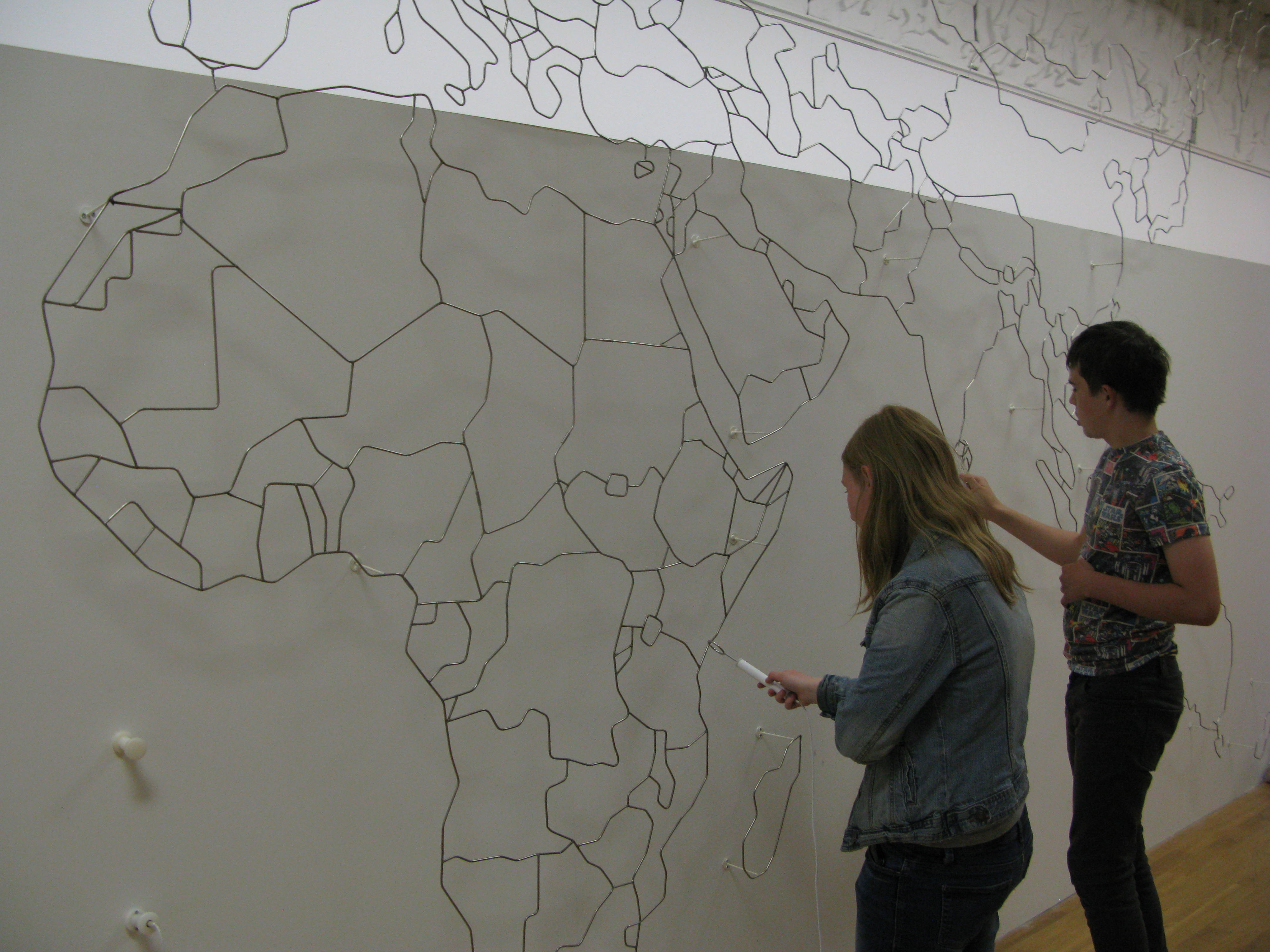
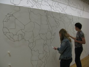
The Current Situation is a collection of work by artist Yara el-Sherbini, whose centrepiece is an interactive sculpture of a map of the world. It is large, 7.8m wide and 3.5m high with steps leading up to the rear. I saw it at its current location in Wolverhampton Art Gallery. I popped in whilst I was surveying some listed buildings (heritage buildings for readers not in the UK).

The work is an impressive sculpture but its true nature is not revealed until the audience engages with it. As you can see from the picture it emulates a children’s game where you have to trace around the object with a metal implement without touching it. Here you trace around the national borders and should you touch one, red lights flash onto the sculpture, buzzers sound and the metal implement in your hand vibrates strongly. Just as in real life, navigating borders becomes a matter of tactics and skill and should you transgress the rules, alarms and shocks await you.

IMG_1056

Again as in real life, some people participate and some watch from the sidelines. It’s only when you play that the real dynamic of conflicts, dangers and exploration becomes apparent. What if no-one plays? Then the sculpture just becomes a beautiful metal map of the world, a static monument which might be seen in many public places around the planet, representing a harmonious, static view of a united world, one that is controlled and restricted.

I found it a clever and thoughtful piece which questions the unspoken cultural components and geopolitical struggles present in a map. You can study a map and only see a small representation of its true content. As the exhibition guide says: ” El-Sherbini’s shock tactic speaks to the physical and legislative strategies used by governments to reinforce and control their borders: from walls, barbed wire, electrical fences, manned and unmanned surveillance, to visa restrictions and immigration curbs.”

The collection is on tour nationally so watch out for it

A visit to view one of the Sheldon Tapestry Maps

posted in: Observations | 1

Friday saw me on a family visit to Oxford to view the Sheldon Tapestry Map of Worcestershire hanging in the Weston Library (part of the Bodleian Library). It is a magnificent spectacle, being woven in silk and wool, and standing some 4m tall by 6m wide. Although it is assumed that it was woven in Warwickshire at Barcheston, current research throws doubt on this.

The Bodleian Library Map Room is the second largest in the UK and is one of the world’s top ten map collections – so it’s a must-visit for any map  lover.

The tapestry on display is one of  four tapestry-woven maps commissioned in the sixteenth century by Ralph Sheldon, a prominent Midlands landowner, based on the county surveys of Christopher Saxton. Each  tapestry illustrates one of the counties of  Gloucestershire, Worcestershire, Warwickshire and Oxfordshire.  They would have formed a panoramic view of Sheldon’s land when hung in his home in Weston near Long Compton, Warwickshire. The maps are an  important stage in the evolution of cartography.

This tapestry survives in parts only: in fact the only complete one is that of Warwickshire which hangs in the Market Hall Museum in Warwick. You can see what was involved in restoring the tapestry here.

There is an intriguing reference to  an area “whych was dryven downe by the removying of the land” close to a placename of The Worldes End.  The Guardian had a good piece about the tapestry , although the mystery of the “removying of the ground” seems to have been solved – apparently it was a massive landslide.

IMG_0941

If  you want an in-depth view of the tapestries see this scholarly article.

It’s good to know that mappa mercia is following an ancient tradition of local map-making although I don’t think OpenStreetMap will ever come close to the beauty and craft of the Sheldon Tapestry Maps.

Highlights from Water Orton

posted in: Map Improvements, Mapping Party | 1

On Thursday 4th June the Mappa Mercia group met in Water Orton on the outskirts of Birmingham, UK, for our monthly mapping event. We had good weather but not everything else went to plan! Here’s a few highlights from our twitter account – you can follow us on @mappamercia.

Despite being briefly stopped by the police (a first for us) we had a great time mapping Water Orton. If you would like to join us next time we will be in Telford. Although details are yet to be 100% finalised it is looking like we will diverge from our normal ‘first Thursday of the month’ to make more of an event out of it. So join us on Saturday 4th July in Telford.

Strava routing errors: Useful or just another MapDust?

posted in: Map Improvements | 3

It is now becoming increasingly difficult to spot errors in OpenStreetMap just by looking at the map on openstreetmap.org. To help we have a collection of quality assurance tools, and this weekend I discovered a new one developed by Strava. The keen cyclists or runners amongst us will recognise the name – Strava is a phone app/service then enables you to monitor your athletic progress over time and compare it against others. To do this it keeps a track of your run/cycle using the GPS built in to your smartphone. Consequently Strava have built up a large database of GPS traces and user contributed map errors. From this they have built a “routing errors” website to help iron out any issues in the underlying map data, which naturally is based on OpenStreetMap.

Strava_routing_errors
Strava’s ‘routing errors’ service (link).

The service highlights 2 different types of errors: those manually entered by it’s users, and those automatically detected from the map data and the recorded GPS traces (e.g. many cyclists riding the “wrong” way down what is a one-way street in OpenStreetMap suggests that the OSM data may be incorrect).

I’ve had a quick play with this new quality assurance tool (with mixed results), but I’d love to hear your views. One concern is that the manually submitted “errors” may be a problem with user behaviour or the Strava app itself, rather than an issue with the OpenStreetMap data, al la MapDust – a similar, and now quite dated service from Skobbler. But is this view too pessimistic? Is there useful data in the manually submitted errors? And how about the (US only) automatically detected errors? Are these a reliable source of quality assurance data for OpenStreetMap?

Let us know your views in the comments section below and feel free to share any other great QA tips you may have.


“We need to think about smartphone editors”

posted in: Observations, Participate | 3

During the cold, wet days of a UK winter it is tempting to contribute to OpenStreetMap via the comfort of your own living room. Unlike when OpenStreetMap started in 2004 this is actually now a reasonable way to contribute to the map – we have high quality aerial imagery (including that from Warwickshire County Council), a licence compatible version of ‘StreetView’ courtesy of Mappillary, and numerous OpenData data sources.

Despite this we do still encourage contributors to get out and map ‘on the ground’. The benefit of an on the ground map survey is that you are always seeing up to date data (what is there now, rather than months/years ago when imagery was recorded) and you get to learn many of the intricacies of the environment around us. It can also really fun!

So how easy is it to be a mapper ‘on the ground’? According to seasoned mapper, keen cyclist, and Potlatch developer, Richard Fairhurst, it’s not easy enough. In this fascinating talk at State of the Map US last weekend Richard makes a plea for OpenStreetMap apps for iPhone and Android. A lot has changed in the last 10 years and OpenStreetMap needs to keep it’s tools up to date whilst continuing to make it easier to contibute to OpenStreetMap.

Introducing smart editors…