Mysterious objects: No 5 in an occasional series

posted in: Observations | 1

I was out walking in the Warwickshire countryside last weekend and came across these unusual objects. Each one was numbered and no more than a couple of meters from the next numbered object. I saw two sets of at least 100 of these, and now release they are located in hedgerows or tree-lined field boundaries that HS2 will cut through (if built).

A small black box (2 by 2 inches and about a foot long). One end is closed and the other end has a small woodern lip.Any ideas?

Mapping transverse steps

posted in: Observations, Participate | 3

How do you map steps that are transverse like these? This is a view towards Birmingham Central Library from Victoria Square and is a route traversed by thousands of people a day.

Currently highway=steps is for a set of steps along a linear way which doesn’t address this scenario which must occur tens of thousands of times across the planet.

There is a tagging proposal which as been around for a couple of years which seems to be going nowhere. I’ve read it and it’s far too complex for  me and I would guess most mappers.

Solving this problem is important a) for accurate mapping and  b) for disabled/visually impaired routing.

Perhaps a simple tagging scheme of highway=steps steps=transverse with the left hand side of the way being the top with a rendering of the current steps render with little arrows pointing in the downwards direction across the way?

While we’re at it perhaps the existing linear steps render could be improved with an arrow indicating down? But maybe that would be confusing with the one way render for streets/roads.

Mysterious Objects: No 2 of an occasional series

posted in: Observations | 5

This object has been a puzzle for a couple of years. It’s been constructed on land alongside an old railway siding adjacent to Small Heath Bridge Birmingham B11. This picture was taken from a train on the way into Birmingham Moor Street.

It’s pointing vaguely westwards, i.e which is the direction the camera is pointing in. The reverse side is a  highly polished surface (stainless steel?). It looks like it might be a solar collector of some kind but there are  no power cables or fluid/gas pipes that I can see so it remains a mystery.

Any offers of what it might be?

40 year old spaghetti

posted in: Observations | 1

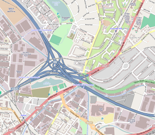
Spaghetti Junction is 40 years old this month; having opened for traffic in May 1972. Its official name is  Gravelly Hill Interchange and forms J6 of the M6 where it meets the Aston Expressway. The name of Spaghetti Junction was coined by Roy Smith, a journalist on the local newspaper; and it is still  the name by which it is known, much to the annoyance of officialdom.

Now to many people in the world a junction of this scale and complexity is no big deal, but in 1972 it was an engineering,  social and transport wonder to the population of Britain. After opening it was soon carrying 40,000 vehicles a day. Today it carries 5 times that volume of traffic and is subject to regular maintenance and strengthening to keep pace with the traffic flows.

It took 4 years to build  the  30 acres (12 ha) junction, which serves 18 routes by means of 4 km (2.5 mi) of slip roads. Interestingly the junction contains only 1 km (0.62 mi) of the M6 itself. Just to add to the complexity of the engineering task the junction sits atop of 2 railways, three canals and two rivers. The solution required 5 different levels, 559 concrete columns, reaching up to 24.4 m (80 ft) and a 21.7 km (13.5 mi) elevated section of motorway.

It was similarly difficult to map it for OSM, so congratulations to the pioneer mappers who had this junction mapped in the very early days of OSM when there was not much more on the map of the UK than the coast and the motorways.

The Aston Expressway (designation A38(M)) is also a transport oddity, being the only single carriageway motorway in Britain. It consists of 7 lanes and operates a tidal flow into and out of the city: more lanes into Birmingham in the morning and more lanes out in the evening. It is also odd amongst UK motorways in having a maximum speed limit of 50 mph.

According to the Guardian newspaper, a poll of drivers nominated Spaghetti Junction as the most terrifying junction in the country, with many drivers opting for diversions of many miles in order to avoid it.

To celebrate the anniversary Dunlop, the tyre manufacturer, based at nearby Fort Dunlop where it manufactures tyres for motor-sport, organised a ten truck convoy to converge on the junction from different routes for an aerial photograph marketing shot. Dunlop reckon they have shipped over 10 million tyres across the junction since it opened.

More canals than Venice?

posted in: Observations | 8

“More Canals than Venice” is something you’ll hear often in Birmingham or from Brummies anywhere, to describe the city. It’s mostly a defensive mechanism, I believe, because Birmingham does not enjoy the best of reputations in the nation’s affections and is  the butt of many a joke. It’s repeated incessantly,  completely oblivious of perhaps better claims from cities like St Petersburg or Amsterdam, which have the added advantage of being much higher in the tourist destination stakes than Birmingham. (Though curiously one of the few boom sectors in Birmingham is hotel construction, with increasing numbers of visitors filling the rooms once they’re completed.)

Perhaps those with the database skills could analyse the OSM data and settle the argument once and for all – which city does have the most canals?

However Birmingham does have one unique claim to fame: a canal roundabout at the junction of the Birmingham and Fazeley Canal and the Birmingham Canal Navigations. And yes, it is tagged with junction=roundabout, although I don’t know whether the direction is correct as I’m not a boat navigator and don’t understand the “rules of the road” for boats. There are certainly no oneway signs present. And I’ve never been present when boats are going round it so I haven’t seen which direction they take.

Birmingham’s canals were built for commercial heavy-lifting during the Industrial Revolution and until fairly recently were woefully neglected. There are still large stretches which pass through industrial areas which can be pretty grim waste-strewn and graffiti-heavy thoroughfares. In contrast, around the City Centre there have been lots of developments of waterside apartments and cafés and nightspots using the canals as an attraction. You have to understand Birmingham is one of the few cities in the world not sited on  a major river so water has a special attraction for the city’s inhabitants and visitors. We even have a waterbus which plies the short distance from the Mailbox (an upmarket shopping mall) to the NIA (National Indoor Arena – a major indoor sports and event venue). It’s mainly used by tourists: locals find it quicker and cheaper to walk.

It makes a strange journey to cross the city via its canals, avoiding the traffic and not being aware of the usual landmarks. All your usual mental landscape of knowing where you are evaporates and you look at the city in a new way. On the subject of avoiding traffic, the canal towpaths make excellent cycle routes and are used regularly by the city’s cyclists.

If you visit Birmingham, take half an hour to descend from its streets to wander along its canals – you’ll come away with a  much better impression of the city – not comparable perhaps to Venice, but better than when you arrived.

Birmingham: the less glamorous side

posted in: Observations | 0

Regular readers of this blog might have the impression that Birmingham is filled with splendidly maintained examples of architectural heritage, as I try to liven up mapping on the ground by centering surveying trips around them. Nothing could be further from the truth!

Owning a listed building is an onerous (i.e  expensive) undertaking. Whilst wealthy businesses and individuals, and large state institutions can enjoy the prestige that occupying such buildings confers upon them, for others it’s more of a struggle. Often the National Trust or English Heritage have to step in and rescue buildings that are in peril. But their budgets are not limitless so few can be rescued in this way. Birmingham Civic Society also does its best to preserve listed buildings that are in danger within the City, but with even more limited funds.

Not only are owners restricted on how they can adapt and extend their buildings, in order to maintain their architectural integrity, but they are often restricted to using original materials. Original materials are rare or non-existent and have to be specially manufactured, sourcing both of which is expensive. Then craftsmen skilled in using such materials have to be found and hired, again at premium rates. All this makes the planning process even longer and more complicated than usual, adding to project timelines and costs.

It’s not surprising then that some owners just give up and let these building slide into decay, as some of these pictures show. The building covered in scaffolding is to prevent it collapsing, not an indication it’s being refurbished. The buildings shown here are all within a 5 minute walk within the Jewellery Quarter, which las led to a whole area becoming blighted as far as development is concerned. (Generally the Jewellery Quarter’s large and varied population of listed buildings is very well-maintained and has been the subject of previous blogs). Trying to persuade developers to enter such areas is yet another headache suffered by City Council planners.

The cynical amongst us might well suggest that the owners are hoping that the building eventually has to be demolished purely for safety reasons, which then gives them a free hand to develop the site.

Surveillance gone mad?

posted in: Observations | 3

Can anyone beat this for density of surveillance cameras?  I know we live in a security-conscious world but I think this is a bit excessive. Spotted on Broad Street in Birmingham between the Hyatt Hotel and Symphony Hall. Or maybe there is a technical reason for this configuration? They seem to me, as a non-expert, on cursory examination to be capable of  horizontal 360 degree rotation.

Has anyone noticed the growth of ANPR (Automatic Number Plate Recognition) cameras at the exit of many motorway service stations?

Whilst on the subject of ANPR cameras, there was a major national news story last year about a blanket installation of ANPR cameras in the mainly Muslim areas of Birmingham, financed by a counter-terrorism budget and erected without local consultation. After a short and controversial political battle they were removed.

Now they seem to be sprouting up on many trunk roads and major routes into and out of Birmingham, so that the entire city is covered. Has anyone else noticed them? Are they sprouting up in other cities? I think there has long been a ring of such cameras around the City of London (the financial district)