What lies beneath?

I know we have enough on our hands with mapping what we can see: but what about what’s under our feet (or wheels)?

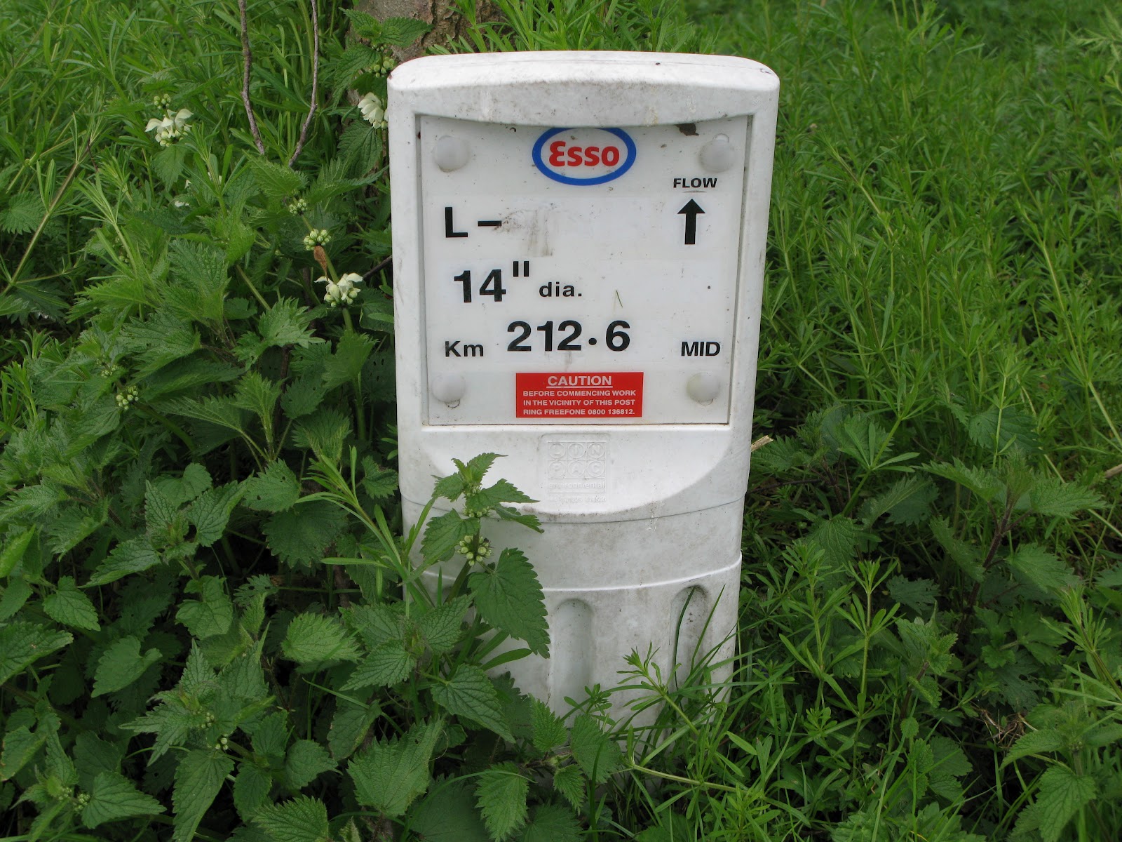
On my travels around the West Midlands countryside I regularly come across pipeline markers like the one illustrated. Depending on my route I can often join up the markers to trace the corresponding  underground pipeline. The oil pipelines carry a  lot of information as you can see which is why they get photographed.

They are a lot less common than the gas pipeline markers which are a boring white pipe about 2.5m high with a fluorescent orange top. These carry a lot less information just usually who you can ring in an emergency. Some have serial numbers but  by no means all. Where one can be seen in the distance but can’t be reached because there are no rights of way to it , the fluorescent marker allows a compass bearing to be taken and a distance estimated for later editing against Bing imagery.

Some pipeline markers have bright fluorescent roofs on them making them look like an arrow pointing skywards. They are numbered and are apparently designed for locating by aerial imagery, although I’ve yet to be able to discern one at Bing’s resolution.

The West Midlands has several oil pipelines crossing it, with at least 4 large oil terminals: BHX Airport; Kingsbury; Fort Dunlop; and Bedworth in our region so we get to see a lot of pipeline markers.

Linewatch runs an excellent website with information to help in preventing builders and civil engineers digging up and damaging pipelines. The page here has a great collection of pictures of what the different companies’ markers look like. In urban locations they can be  much more unobtrusive and consist of brass plaques mounted in the pavements. I’ve hunted for them around the Fort Dunlop terminal but without success so far. It might make a good treasure-hunt type of mapping party! My wife just thinks I’m nuts when I get excited about coming across one of these markers on our walks representing as it does, another piece of the jigsaw puzzle. She is good enough to point out ones that I’ve missed though!

There’s also a good schematic map of where the pipelines go. Very detailed locations, which are copyrighted, can be found  at a related membership site Linesearch, which is off-limits to us OSMers and is really for on-site contractors operating digging equipment.

Birmingham is also the termination point of the Elan Valley Aqueduct, a (largely) buried pipeline bringing  water over 73 miles (118 km) from the Elan Valley reservoir in mid-Wales. Water travels at about 2 miles per hour along the pipeline taking about one and a half days to reach Birmingham at the Frankley reservoirs. It was built over 100 years ago, between 1893 and 1904 and is an engineering marvel, dropping only 52m over a length of 118 km – a gradient of 1:2300. The water arrives by gravity alone with no assistance needed from pumps. Whilst most of it is underground there are stretches of overground pipeline and there are  aqueducts bridged over rivers and the odd brick-built valve house. It was mapped with the aid of out-of-copyright Ordnance Survey maps.

Interestingly there is a large network of state-run pipelines known as GPSS (Government Pipeline and Storage System) largely for supplying military installations and is a hangover from World War II and Operation PLUTO (Pipeline Under the Ocean) prepared for supplying the D-Day landings.

As none of this gets rendered, why should anyone get excited about unseen, underground pipelines. Well, firstly there’s the intellectual satisfaction of working out what all the surface paraphernalia relates to and also of linking it altogether in a network. Secondly there’s a sense of completeness in mapping how energy, water and other industrial requirements traverse the planet. Thirdly if we’re given a tag which shows up in the editors (well it does in JOSM – I haven’t checked in Potlatch) then I suppose we’re duty-bound to use it!

Do other mappers in parts of the world, where land is not at such a premium as it is in the crowded islands of the UK and pipelines can  constructed above ground, map them? If they’re a major landmark shouldn’t they be rendered?

Perhaps the nice folks at ITOWorld will give us a rendered layer of pipelines?

Is there a way of joining the surface links of a pipeline such as reservoirs, terminals, pumping stations, venting stations, refineries, chemical works together in a relation?

Currently I indicate direction of flow with a oneway=yes tag where this can be ascertained from the  above-ground marker, which results in an error message nag from the editor and lots of little arrows rendered that are attached to nothing. So if you see one of these arrows and are wondering what on earth it can be – I’ve been mapping pipelines beneath you.

Musings on the psychogeography of addr:housenumber=13

posted in: Observations | 2

Within the West Midlands we have surveyed and edited many thousands of addresses. It can be tedious work, made more frustrating by a simple error that everyone makes initially. This is recording the first and last house numbers in a row of houses when out surveying and later at home trying to allocate the house numbers to traced building outlines only to realise they don’t fit for odd number ranges. Guess what? Our logical minds assume that odd numbers progress incrementally and that includes the number 13, but the irrational, superstitious mind doesn’t want a house with an “unlucky” number. So many rows of odd-numbered buildings jump from 11 to 15, omitting the number 13.

Now 13 isn’t an unlucky number in all cultures so we wonder if there are other house numbers that are avoided in other countries. Perhaps also there is  variation within cultures where 13 is unlucky with different tolerances to the house number 13 in different countries and regions? And similarly for other “unlucky” numbers?

An added complication to surveying is that avoiding house number 13 is not universal. Victorian and Edwardian houses (c. 1800-1914) have no such inhibitions. The practice seems to have crept in somewhere in the 1940s and 1950s becoming more prevalent so that new housing developments (from around the 1990s) NEVER have a number 13. We can’t be precise about the changeovers because we haven’t done a scientific analysis, so this is just a rough “feel” for the data. Maybe someone, somewhere has done the analysis. If it hasn’t been done – perhaps there’s an opportunity for  an academic research paper.

Also some new owners have “retrofitted” older houses which were numbered 13 as 11A! Again we haven’t analysed whether this is just cosmetic or whether there are legal and administrative processes for the Post Office and local authority to record the change in official databases and legal documents such as title deeds.

It seems that the Victorians and Edwardians  lived in a more rational age, closer to the Enlightenment and more optimistic about scientific and technological progress. A century later with even more scientific and technological progress (think powered flight, atomic power, computers, the Internet, TV, DNA, antibiotics and so on and so forth) and an understanding of the universe several orders of magnitude greater, yet we’ve reverted in a basic social function to a more irrational and superstitious practice.

Perhaps the randomness of survival and death in two World Wars played a part; but contrary to this, earlier generations faced high mortality rates through natural causes: disease.

A mapping blog is probably not the place to solve such puzzles, but we can map the data and leave others to worry about them. Anyway it provides another instance of how mapping can reveal hidden trends which lead into unexpected lines of inquiry.

Is this the most architecturally elaborate substation ever built?

posted in: Observations | 3

To make adding buildings to OSM slightly more interesting, I’ve been targeting listed buildings (for non-UK readers these are legally protected buildings and structures that have historic or architectural significance, with strict rules on alteration and preservation). Obviously the graffiti painters are excepted from these rules!

This gives me some motivation for surveying and provides some welcome relief from what can be a tedious process. Further web and library-based research can also be rewarding.

So imagine my surprise to see a humble electricity substation appearing on the list. Intrigued, I set off for the Selly Oak area of Birmingham and found this gem just off the Bristol Road, behind the library.  Either energy prices were even more of a rip-off when this was built, or architects and engineers were given more scope to exhibit civic pride in their work. I like to think it was the latter.

Has anyone else anything better in the way of ornate electricity substations?

Birmingham prepares for winter

posted in: Observations | 0

This statue can be found in the heart of the Bullring retail complex right in front of the Rotunda. I was tempted to tag it with woolly_jumper=yes!

For those of you reading this from outside the UK who think the English are kind to animals I bet you didn’t think we were kind even to statues of animals.

Birmingham’s Custard Factory

posted in: Observations | 0

If this statement is true, and I believe it is, then an OSM map of a city  is meta-art!

This sign adorns the Custard Factory in Digbeth, close to the City Centre; now a thriving arts and media hub with many small businesses located there. As the name suggests it was originally home to Birds Custard manufacture.

Architectural Heritage in Edgbaston

posted in: Observations | 0

It seems that just about every other house in Edgbaston is listed!
(for non-UK readers a listed building is deemed to be of architectural or historic merit and there are strict planning rules as to what you are allowed and not allowed to do in altering and maintaining it).

As you can see from the map below it’s a historic part of Birmingham, mostly where the old industrialists lived and thanks to the Calthorpe Estate and the proclivities of said nineteenth century industrialists there weren’t many factories or pubs or cheap back-to-back housing built there (all the yellow buildings are listed)

A few  examples of listed buildings in the area:

As you can see it’s not a cheap area of Birmingham to live in, even today.

A Good Read

posted in: Observations | 0

This book, written by a couple of poets takes you to all those places that only mappers have visited repeatedly to lovingly survey and map every detail. Edgelands  addresses all those betwixt-and-between places that aren’t really urban and aren’t really rural and are certainly not loved or cared-for. They’re the kind of places we hurry through to get somewhere else or the kind of places that we just don’t acknowledge exist at all. You know the kind of places: brownfield sites, abandoned parking lots, sewage plants, power plants, abandoned construction sites, out-of-town shopping malls and industrial estates after hours. The poets talk about them reverentially and find a stark and melancholy beauty there.

The bookjacket blurb puts it excellently:

“Edgelands explores a wilderness that is much closer than you think: a debatable zone, neither the city nor the countryside, but a place in-between – so familiar it is never seen for looking. Passed through, negotiated, un-named, ignored, the edgelands have become the great wild places on our doorsteps, places so difficult to acknowledge they barely exist”.

But us mappers have been there and struggled with all their idiosyncrasies and even dynamism as they change use,  in our quest to leave no white space on the map.  Enjoy a different perspective of these places.

ISBN 978-0224-08902-9 published by Jonathan Cape

Going Going Gone!

posted in: Observations | 0

Stephenson Tower, a block of council flats built in the 1960s adjacent to New Street Station is currently under demolition brick by brick. The demolition method and the cocoon is to prevent  dust and protect signalling equipment and the telephone exchange in Hill Street. The demolition is part of the renovation of New Street station due for completion in 2015. More details from the project here.

Tolkien’s Two Towers

posted in: Observations | 0

These two towers – Perrotts Folly and the Edgbaston Waterworks Tower – are prominent landmarks about 600 metres apart in the Ladywood area of Birmingham. As a child, Tolkien lived in numerous addresses in Ladywood and it is reputed locally that these towers are the basis of the ‘Two Towers of Gondor’ – Minas Morgul and Minas Tirith.

This is Perrott’s Folly (above), built in 1758 by John Perrott. No-one knows for sure why he built the tower so it’s called a folly. It was used as a weather recording station from 1884 to 1979.

This is the tower at Edgbaston Water Works, built in 1870. Although the Water Works is adjacent to a large reservoir , there is no connection – Edgbaston Reservoir was built to supply water to the canal system not the domestic supply.

An obscure saint in Yardley

posted in: Map Improvements, Observations | 1

Yardley Old Village is a haven of rural peace set in the middle of the suburban expanse of East Birmingham. There is a cluster of listed buildings around the mediaeval church of St Edburgha, which includes an old farm and a working blacksmith. The church is currently swathed in scaffolding so no picture I’m afraid.

St Edburgha ( pronounced edburra) was grand-daughter to King Alfred and her relics are in Pershore Abbey whose full name is  the Abbey Church of Holy Cross with St Edburgha. I’m not sure if there are any other churches dedicated to her.

On the way there I surveyed  the new route of the A4040 Church Road, opened this week to accommodate the controversial development of a new Tesco store. The road still awaits a roundabout at its northern end, so the bus route relations haven’t been updated yet. Let’s see how long it takes other map-makers to update this stretch of road.