Following on from the tweet summary from Andy’s (@pigsonthewing) Wikidata presentation at State of the Map 2015, you can now watch the full talk:
OSM UK Quarterly Project No 2 “All things delivery-related”: an update
It’s now May and the project is a month old and with two months to go, it’s time for an update.
Robert Whittaker has an excellent site monitoring OSM data on postboxes in the UK. Here you can see progress (even a league table of who’s contributing). From the history graph you can see there’s been an increase in activity since the project got going. Perhaps Robert might provide some data analysis about the effect of the project.
Enter a postcode and you can find all the missing and incorrect postboxes nearby. I was amazed at just how many were missing in the areas I map regularly: a great incentive to revisit all kinds of places. In doing so I discovered one of those rarities: an EVIIIR royal cypher(OSM node 448635608).
(For non-UK readers King Edward VIII was only on the throne for about 11 months in 1936 before abdicating so there are only about 130 postboxes bearing the royal cypher EVIIIR, these being the ones installed during those 11 months)
How many of these are actually recorded in OSM? It would make a great treasure hunt for the rest of the project. From web research I think there are only 2 in Birmingham so my job’s done.
I’ve been unable to track down some of the indoor postboxes – two in particular are indicated in Sainsbury’s supermarkets near me, but neither exists. This led me to wonder whether Sainsbury’s had some kind of agreement with Royal Mail which didn’t work out so they were removed. But you can’t build a hypothesis on two pieces of data! Does anyone have any knowledge of this? Or replicate my findings?
In the West Midlands we’ve had some fun trying to locate the Coventry ParcelForce depot which is NOT where Google thinks it is. It moved over two years ago and is now mapped in OSM . Thanks must go to our local sleuth: spiffymapper.
Parcel Lockers are poorly mapped – only 8 existed in OSM for the UK at the start of the project. Now there are 11 . It turns out that one of the operators, ByBox, has its national distribution centre in Coventry so time for spiffymapper to get his sleuthing shoes on again!
Any other stories on what folk have been up to on this project are welcome.
New UK Quarterly Project (April-June)
New month, new quarter, new project.
Our first attempt at a quarterly project has just finished, where fixing road names was the target. I’m sure there was an uplift in the rate of clearing these up and a big thank you to everyone who took part, but we don’t have any formal metrics (perhaps ITOworld might do some analysis on comparable rates across quarters) and there’s still a way to go to clear the total number of mis-named roads. What is clear is that there’s not enough mappers on the ground to tackle something basic like this and we don’t have a scalable method for contacting existing and potential mappers. I guess maintaining a map isn’t as exciting as creating one! Anyway as we proceed with quarterly projects hopefully we’ll evolve how to solve both problems.
Our goal with quarterly projects is obviously to improve the map in a co-ordinated way but also to try and develop the UK mapping community by reaching out to new audiences and to re-energise existing and lapsed mappers.
So, on to our next project: all things delivery-related
This could be Royal Mail postboxes (still loads to do); Royal Mail delivery offices and sorting offices; delivery areas/gates to factories and town centre shopping malls; maxheights and maxweights on roads; courier depots; distribution warehouses; new internet shopping parcel lockers (see wiki entry); there’s a new parcel-collection service based around mainline stations called Doddle.it; airfreight facilities; railway marshalling yards; secure lorry parks; port/dock facilities and anything else you can think of. All suggestions and stories welcome.
Data update for UK Quarterly Project: road name fixing
Now that Itoworld have resolved their technical problems we can see if the Road Name Quarterly Project is having an effect. Here are the top 20 local authorities from Itoworld’s OSM Analysis service:
| Rank | Area |
Roads in OS Locator |
Road missing from OSM |
Percentage Complete |
Missing Change Last Day |
Missing Change Last Week |
Missing Change Last 30 Days |
| 256 | Manchester | 6,941 | 152 | 97.74 | 0 | -46 | -46 |
| 369 | Rochdale | 3,666 | 164 | 95.44 | 0 | -31 | -31 |
| 267 | South Staffordshire | 2,092 | 47 | 97.56 | 0 | -17 | -18 |
| 355 | Knowsley | 2,268 | 82 | 95.72 | 0 | -17 | -17 |
| 273 | Cannock Chase | 1,514 | 36 | 97.42 | 0 | -16 | -16 |
| 122 | Blaby | 1,598 | 5 | 99.69 | 0 | -13 | -13 |
| 139 | Bromsgrove | 1,693 | 8 | 99.53 | 0 | -9 | -9 |
| 400 | South Northamptonshire | 1,581 | 63 | 94.81 | 0 | -9 | -9 |
| 214 | City Of Nottingham | 3,601 | 42 | 98.56 | 0 | -8 | -8 |
| 297 | Bedford | 2,213 | 48 | 96.93 | 0 | -8 | -17 |
| 105 | Bournemouth | 1,766 | 2 | 99.83 | 0 | -6 | -6 |
| 321 | Lichfield | 1,738 | 54 | 96.43 | 0 | -6 | -11 |
| 103 | North Wiltshire | 2,249 | 3 | 99.87 | 0 | -5 | -4 |
| 159 | County Of Herefordshire | 2,723 | 15 | 99.34 | 0 | -5 | -6 |
| 340 | Daventry | 1,625 | 62 | 96.06 | 0 | -5 | -5 |
| 3 | South Gloucestershire | 3,629 | 0 | 100.00 | 0 | -4 | -4 |
| 113 | Ashford | 1,893 | 4 | 99.79 | 0 | -4 | -4 |
| 142 | Ellesmere Port And Neston | 1,395 | 7 | 99.50 | 0 | -4 | -4 |
| 157 | West Somerset | 914 | 6 | 99.34 | 0 | -4 | -4 |
| 357 | Horsham | 2,167 | 81 | 95.71 | 0 | -4 | -4 |
Thanks to all the mappers who have participated, including those not in the top 20: if you’ve only got a couple of roads left to check you’ll never appear in the top 20 but your contribution is just as valuable.
Congratulations also to those who’ve got their local authority area to the 100% mark recently: Torfaen; Dover; Gwynedd; Powys; West Lothian; Wolverhampton; and South Gloucestershire.
It would be nice to personalise this but I don’t have the necessary skills to identify the users programmatically, or the time to do it manually. Maybe privacy concerns suggest it’s not a good idea but the whole idea behind a quarterly project is to build more community engagement and co-operation so we do need to get to know each other (especially those who aren’t veteran mappers or denizens of mailing lists and chatrooms)
Currently we don’t know whether our quarterly project experiment has incentivised people to go out and tackle this problem or whether it would have happened anyway. Any feedback would be appreciated.
Reaching a new audience in the UK
At our monthly mappa-mercia pub meeting we were chatting about new ways of encouraging participation in the current quarterly project to fix street names. It seems that there are people who both contribute Notes and comment on them who might not be on talk lists nor be aware of the OS Locator data which highlights name problems. So we thought that adding Notes about road names that need fixing on the standard OSM map, asking for confirmation of the correct name might elicit some response via a comment indicating the correct name. This could then be edited by a mapper.
Potentially, by using this method we would address a new audience who are prepared to add data occasionally but don’t want to be hard-core mappers.
This method would work best for situations where OSM and OS Locator have different road names.
We’d like to try this in an area with a high density of road name fixes and few active mappers. Liverpool, Rotherham and Manchester look to be likely candidates (258, 225 and 198 road name fixes respectively). If there are active mappers in these areas who don’t want this to happen please let us know soon and we’ll keep away. You could of course volunteer another area, either for us to pilot or to do it yourself.
If we don’t get a sufficient response to our Notes we would follow up with web searches for local community groups who have twitter or facebook accounts and ask for their participation via those media.
Fixthatroadname! reveals a surprise discovery
What makes contributing to OSM so enjoyable is the unexpected discoveries it throws at you. Today I went surveying in West Bromwich to resolve two OS Locator road name issues. Neither was in any remarkable and apart from adding a few addresses and POIs not very productive. In mitigation the weather was rather foul and not conducive either to writing notes or taking photos.
But once home and conducting some web research on the area I came across this Daily Mail article concerning the misnaming of a road named in honour of a local WWI hero, winner of the VC (Britain’s highest award for bravery).
The soldier’s name was Robert Edwin Phillips and the council had mistakenly named the road Edwin Phillips Drive . Rather than re-name the road correctly, mainly because residents objected according to the Daily Mail article, the council decided to add a supplementary plate reading ‘Commemorating West Bromwich-born Capt. Robert Edwin Phillips V.C., 1895-1968. Awarded the Victoria Cross during the First World War.’
Only three more names road names to resolve in Sandwell ( the council in whose area West Bromwich is located): I wonder what surprises are in store?
Surprise yourself – go out and survey some OS Locator name mismatches!
FIX THAT ROAD NAME
We’re trying to build the UK OSM community with Quarterly Projects – our first project is FIX THAT ROAD NAME.
If you’re new to all this then the first port of call should be the OS Locator wiki page.
It’s a good idea to have the OS Locator imagery layer ON during editing so you can see where there are errors as you edit. Advice on how to do this is on the OSM and OSL differences tileset page
GOLDEN RULES
1.Concentrate on areas you know well and can reach easily in case a survey of the road name is required
2.If an OSM road has a name that is different from the OS Locator name then it definitely should not be changed UNLESS you have definite local knowledge OR you have surveyed it.
3.If your name for the OSM road is different from OS Locator then once you’ve corrected or entered the name you need add the tag not:name= nnnnnnn where nnnnnn is EXACTLY the OS Locator name.
4.If an OSM road has no name but OS Locator has then you MAY add the OS Locator name AS LONG AS you add the tag source:name=OS_OpenData_Locator. This is because OS Locator often has an incorrect or mis-spelled name and this enables other editors at a later date to scan an area using this tag to further improve the data should this be the case. There is a division of opinion amongst veteran mappers about this: many hold that ONLY surveys are legitimate, but as long as you tag with source:name=OS_OpenData_Locator then this is acceptable as the vast majority of OS Locator names are correct.
There are some special cases which will be dealt with in a separate blog.
If you need help then either subscribe to the talk-gb mailing list. Instructions here
or email or phone your query to us using one of our contacts
And don’t forget – as you correct and add road names you’ll always find other things to improve!
Suggestion for OSM UK quarterly projects
At a recent pub meeting mappa-mercia mappers felt that UK OSM contributors are all busy on their own specific projects and apart from the occasional discussion on the talk-gb mailing list don’t really get together as a community. Compare that to the Irish community where there is a real drive on one large project to complete the mapping of townlands by 2016. There’s a real buzz about this with some fantastic tools and data visualisations, chat, problem solving, and a great series of instructional videos. You feel a real part of a community if you participate.
So to try and rectify this we’re starting a campaign in the West Midlands, which we hope will be adopted by mappers all over the UK. Each campaign will last for 3 months – plenty of time to achieve something big, work together as a community on a common goal, whilst leaving you time to work on your own projects alongside.
Task 1: Check that road name!
The first task is to add missing road/street names and to correct misspelled or misnamed roads. Reasoning? This is a basic geographic data requirement for a map and we have some way to go in the UK to achieve completion.Until we complete this we’ll always lack credibility.
This task has been slowly ticking along but it’s currently both lonely and tedious. There’s a great opportunity to get out to some areas that haven’t been touched for some time; come up with some new ideas to involve newer mappers, reactivate mappers who have ceased mapping, possibly even coordinating with housing developers to keep OSM right up to date. And more…. we’re looking for ideas and actions to reach out to develop a community here.
The latest release of OS Locator data gives everyone the opportunity to get out there and chase down the latest set of road name revisions. ITOworld’s OS Locator tracker shows us at 98.14% completion. There are 14,639 major issues and 2,125 minor issues (mostly involving the use of apostrophes). (You need to register to use this tool).
If we take the end of the quarterly project as March 31st 2015 we need to correct 197 road names a day to achieve completion. We’re so close, if we get enough momentum this is achievable. Even if we only double the current rate of completion that would be a big slice off the target and we’ll have started to build ourselves into a community that does things together.
Watch out for more blogs, posts and chat about this project. All ideas discussion and action welcome!
A missing ‘l’ adds 5 miles
When I first started contributing to OpenStreetMap there was a Project of the Week section on the OSM wiki. After much success this eventually came to and end in July 2011. Now, after a three year break, its back in the form of a “wochenaufgabe” (weekly task), for it is the German OpenStreetMap community that has brought back this weekly project.
This weeks task revolves around adding street names to buildings and suggests contributors use the Geofabrik OSM Inspector tool I previously blogged about. Given that I recently helped to map buildings as part of our Shenstone meet-up, I thought I best check the quality of our evenings work.
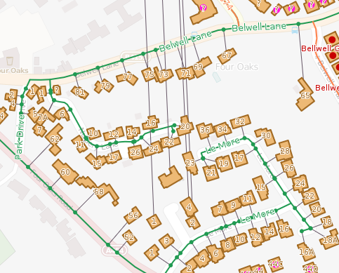
As it turns out, my attention was quickly diverted to the neighbouring town of Sutton Coldfield. As shown in the image above there are a collection of houses in Four Oaks that have a street name that links to Aston Close in Shenstone, 5 miles north (as seen by the lines heading north from each property). The buildings are tagged with addr:street=Aston Close, whilst the nearby Sutton Coldfield street is tagged name=Alston Close. So which is correct – Alston or Aston. We could go back out an survey this close, or turn to OpenData in the form of Land Registry’s Price Paid data.
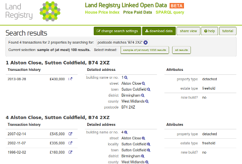
A quick search of the Price Paid data identifies the Sutton Coldfield street as Alston Close. No longer will you end up 5 miles out of the way next time you use OSM to route to this street.
Checking for errors in address data
I’ve slowly been getting in to mapping more residential addresses in OpenStreetMap. In theory this sounds quite an easy task – you have an odd side and an even side of the road, and you count up in 2’s. In practice it can be a lot more complex. Some of these complexities can be quite common, such as skipping number 13, but you also get other missing numbers, double numbers (e.g. 20 and 20A), and houses that disappear round the corner.
So how can I check that mistakes haven’t slipped through? Well, fortunately there are many quality assurance tools to check OpenStreetMap data. For addresses I find OSM Inspector works well. Let’s look at some examples:
Example 1: No matching street
In the picture we see that OSM Inspector shows the buildings, and adds an artificial line linking the building to it’s street (as tagged in OSM). In this first example there are three houses that don’t link to a street. The OSM Inspector tells me that these houses are tagged as being on Underhill Close, a name that is not present on the road nearest these houses.
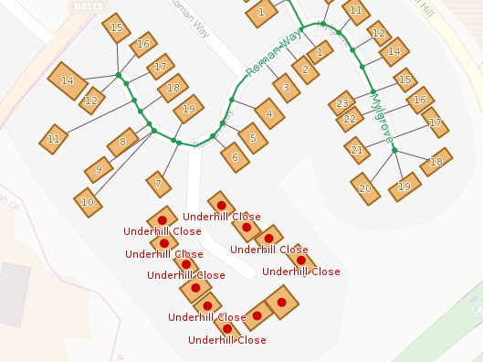
Resolution: The best option here would be to do a ground survey to check for the name on the street, and if you do this you’ll find a sign for Underhill Close. But what if a ground survey is not immediately possible – are there any other sources we can use? Well, we could look at the OS OpenData. I find that OS Musical Chairs is a good site to use. In this case though, the Ordnance Survey don’t have the Underhill Close name (link). Another source is the Land Registry Price Paid data. Using the search form (link), I find this street name in their database.
Example 2: Incorrect street name change
This ones a bit more suitable, but highlights the benefit of mapping residential addresses. In the example the street name changes from Throckmorton Road to St Mary’s Road. I had originally mapped the transition of street name at the intersection with Winchcombe Road (to the north). My adding the addresses it is clear that the transition between street names actually occurs further to the south-east.
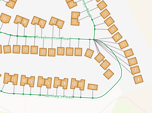
Resolution: In this case we can just change the point at which the street name changes in OpenStreetMap. Somewhere in the south east corner between numbers 83 and 29 will be fine.
EDIT: Why not take a look at what OSM Inspector shows in your neighbourhood.