Heart of England Way completely mapped!

posted in: Map Improvements, Use The Map | 2

On Sunday I completed a short 4Km stretch around Blockley, the last remaining gap in the OSM map.  Thanks are due to everyone who contributed over the years, collaborating in mapping this long distance route.

The Heart of England Way stretches for some 100 miles through England’s Midlands. This route proves that the Midlands does not justify its image of an industrial wasteland. The Way starts in Staffordshire’s heathlands and forest on Cannock Chase and passes through the small city of Lichfield with its three-spired cathedral known as the “Mother of the Midlands”. It then passes between the industrial giants of Coventry and Birmingham, although with  the peaceful countryside it chooses, you wouldn’t know they were there.  Rural Warwickshire beckons as the Way meanders through the remains of the Forest of Arden. The final part sees it sharing much of its route with the Monarch’s Way as it leapfrogs from one cosy Cotswold village to another. It finally ends up in the tourist honey-pot of Bourton-on-the-Water, where it links with the Cotswold Way.

The most popular Guide to the Way by Richard Sale  has the route going the other way, but describing it this way  reflects more the order in which we mapped it.

Official website here
Best map is of course Lonvia’s Hiking map

An obscure saint in Yardley

posted in: Map Improvements, Observations | 1

Yardley Old Village is a haven of rural peace set in the middle of the suburban expanse of East Birmingham. There is a cluster of listed buildings around the mediaeval church of St Edburgha, which includes an old farm and a working blacksmith. The church is currently swathed in scaffolding so no picture I’m afraid.

St Edburgha ( pronounced edburra) was grand-daughter to King Alfred and her relics are in Pershore Abbey whose full name is  the Abbey Church of Holy Cross with St Edburgha. I’m not sure if there are any other churches dedicated to her.

On the way there I surveyed  the new route of the A4040 Church Road, opened this week to accommodate the controversial development of a new Tesco store. The road still awaits a roundabout at its northern end, so the bus route relations haven’t been updated yet. Let’s see how long it takes other map-makers to update this stretch of road.

Ladywood Circus – a "big top" of traffic lights

posted in: Map Improvements, Observations | 0

I drove though here one night and got very confused with the new northbound carriageway going right through the middle of what used to be a roundabout, so I decided to do a survey.  The results are shown below. Is this a record for the number of sets of traffic lights you can fit onto one roundabout? (9 sets and 2 sets of toucan crossing lights!)

Needless to say I couldn’t waste the opportunity so I surveyed some adjoining streets also. I came across what has to be one of the longest  and most evocative church names I’ve ever seen. I don’t know the origins of this church, but I expect it to have been interesting. Has anyone else come across one of these churches?

I also discovered a small patch of rural delight nearby – what a great way to enliven an otherwise patch of waste ground and make our urban life brighter. Congratulations to whoever is responsible. It’s not a great photo but there’s a sea of white daisies awash with poppies.

Whats in a Postcode?

posted in: Map Improvements, Participate | 5

Andy has been busy in B72, the heart of Sutton Coldfield, so exactly what does this mean for our map?

Short answer:
Nearly 3500 residential properties,
Almost 300 named retail units,
Nearly 100 commercial buildings,
All drawn in and with full address details including the full postcode!

Long answer:
Its taken a little over two months, a half hour here and there out walking and cycling the streets to collect all the address data; house numbers, retail names etc. Many more hours at the computer drawing each of nearly 4000 seperate buildings and in the case of residential properties their associated gardens.

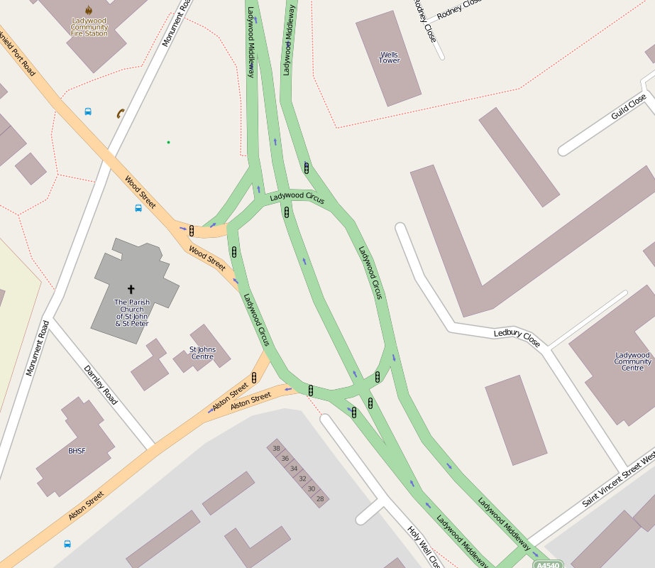
This means that B72 is essentially fully mapped out. Nearly 50,000 objects in all (nodes, ways and relations). Of course we could find more to map even now but the current result is as detailed and rich a dataset/map as almost anyone should ever require.

You can browse the map here or search out an address in B72 using nominatim.

Lessons learnt:
In undertaking an exercise such as this there are always lessons to be learnt. Here’s just a few that may help and spur on others to map their areas in full detail.

  1. Tools that orthogonalise buildings (hit “Q” in JOSM or Potlatch2) are a godsend, also the duplicate and node merge (“M”) facilities when it comes to creating multiple buildings of the same shape and size.
  2. Most traditional retail units have a front facing length of 20 feet (6.1m). Very handy when dividing up long runs of shops.
  3. Postcodes were added using the OS OpenData CodePoint dataset. Postcodes are unique to a particular street (or in some cases particular address) with postcode changes along a street normally occurring at a connecting side street or other natural break (public footpath perhaps). In a handful of cases its impossible to know if a building opposite a side street is in one postcode or another and in these few instances the postcode has been left as a “?” until it can be verified.
  4. When looking at all the property boundaries you find a number of other features that are easily overlooked. Local electric substations being a good example.
  5. There is no easy way to deal with properties with vertically mixed use. For example flats over shops. A longer term solution is needed for these.
  6. Property addresses in private gated roads are difficult to obtain unless you are granted access.
  7. To show all business names in the retail heart of a town or city you really need an extra zoom level (z19) or a method of better dealing with icon and name conflicts on the rendered map.

So what’s next, well of course B72 is just one small area containing just 242 unique postcodes. Birmingham postal region alone has nearly 42,000 unique postcodes so there is a huge amount to do even for our local mapping group and without more help it will take many years. Please help by joining the project, every property and address you add to the OpenStreetMap project means more information available to West Midlands individuals, organisations and businesses.

More: Mappa-Mercia OpenStreetMap user group
Contact us: info (at) mappa-mercia.org

Break out from my urban surroundings

posted in: Map Improvements, Observations | 0

Sometimes I feel the urge to break out from my urban conurbation surroundings and map somewhere all together more rural. I don’t get much time these days to map so it was a real pleasure to head out in the autumn sunshine yesterday on the bike. The destinations I picked were Colwich and Little Hayward which are located between Stafford and Rugeley and were essentially blank on the map save for the A51, the railway lines, canal and the river Trent, all of which run parallel through the area.

One of the things I really enjoy about mapping for OSM are those things that you would never see or learn about (and which you can add to the map) if it were not for getting out there on the ground. Yesterday was no exception but unlike the usual notable place of interest, interesting feature or great view it was a moment to reflect, for I stumbled upon a tiny beautifully tended memorial garden, easily missed and tucked away at the specific spot of a tragic event in 1986, the Colwich Rail Crash, something I really had no knowledge of previously. The garden is now a memorial to two men, Eric Goode the train driver who tragically died in the crash, and Alf Taylor, a retired railwayman who created and tended the garden until his death in 1997. OpenStreetMap gives us the opportunity to place important places in our landscape like this clearly on the map, something I’m always pleased to be able to do. Should you wish to find it yourself it’s here.

New Queen Elizabeth Hospital Opened

posted in: Map Improvements | 1


The three white cylinders of the new hospital have already become familiar sight in Selly Oak but it was only today that the new Queen Elizabeth Hospital finally opened. At the same time the barriers which were blocking of major parts of the new road network for accessing the University and the new hospital site disappeared as well offering a great opportunity to map some pristine roads!

 
So, when I cycled home today I switched my GPS receiver on and made a small detour; the results can be seen on the map.

Kidderminster Mapping Party April 17th 2010


Nine mappers turned out to enjoy a glorious sunny Spring day cycling and walking around Kidderminster to help out Gavin who lives there. As you can see from the map comparisons we covered some miles. We had a splendid lunch accompanied (mostly) by Bathams Bitter at the King & Castle which is on the old GWR railway station (now the terminus of the Severn Valley Railway). Brian had a run-in with an irate landowner and Christophe discovered a blue plaque explaining the history of carpet making (see above). The afternoon was accompanied by the sound of the crowd watching Kidderminster get beaten 2-0 by Stevenage.
(More edits will trickle in so there’ll be a final map soon)

True grit

With the cold weather continuing its been difficult to get out and do the normal level of new mapping so we decided at one of the monthly social meets to do a bit of work that didn’t require much outdoor mapping. Gritting Routes. Birmingham City Council like many other local authorities publish their winter road management plans, including those routes which are strategically important and therefore should be kept clear of snow and ice in the winter. These gritting routes have been added to the OpenStreetMap.org database and a new overlay created from this to add a gritting map to mappa-mercia.org. Solihull has since been added and we are hopeful to add the other West Midlands LA’s data soon too.

The work hasn’t stopped at gritting routes. The location of grit bins, placed by LA’s at vulnerable locations such as steep hills and schools, especially on roads which are not routinely gritted, needs to be located or verified on the ground. We’ve started to add some to the database and now show on the gritting map when you zoom in and more will appear as they are found and verified. If you have a grit bin on your street why not add it yourself or tells where it is and we will add it for you.

All of this has produced some good publicity for the mappa-mercia project. Birmingham has now added a link to our gritting map from its website and to top it all last week we got a short interview aired on the BBC evening news program Midlands Today plus a post on BBC West Midlands Science and Environment correspondent David Gregory’s blog

Great work to all those who have contributed.

Pelsall pleasure

posted in: Map Improvements, Observations | 1

As time ticks by more and more villages within the West Midlands conurbation get completed. This time its Pelsall, a 1000 year old settlement that is now part of Walsall Metropolitan Borough. It’s another old mining village though there is little sign of its earlier industrial past other than the canal that meanders peacefully around its western and northern fringes.

Pelsall is the home of one of the oldest Finger Posts in the country. Recently restored to its former glory it stands at the main principal road junction to the north-east of the village. Naturally such a fine monument has a road named after it; Finger post Drive.

Brownhills Jigger

posted in: Map Improvements | 0

Brownhills is the most northerly town of the West Midlands; a former coal mining centre that used to be in Staffordshire. Its recent claim to fame is the creation of a 30 foot statue of a coal miner know as “Jigger”, a tribute to Jack jigger Taylor, a miner that died in the local pit in 1951. It dominats the centre of town.

Its been an interesting place to map. A real mixture of housing types, landuse and the remnants of the industrial revolution; canals and railways, some of which have been abandonded and now have a second life as footpaths or cycleways.