I’ve slowly been getting in to mapping more residential addresses in OpenStreetMap. In theory this sounds quite an easy task – you have an odd side and an even side of the road, and you count up in 2’s. In practice it can be a lot more complex. Some of these complexities can be quite common, such as skipping number 13, but you also get other missing numbers, double numbers (e.g. 20 and 20A), and houses that disappear round the corner.
So how can I check that mistakes haven’t slipped through? Well, fortunately there are many quality assurance tools to check OpenStreetMap data. For addresses I find OSM Inspector works well. Let’s look at some examples:
Example 1: No matching street
In the picture we see that OSM Inspector shows the buildings, and adds an artificial line linking the building to it’s street (as tagged in OSM). In this first example there are three houses that don’t link to a street. The OSM Inspector tells me that these houses are tagged as being on Underhill Close, a name that is not present on the road nearest these houses.
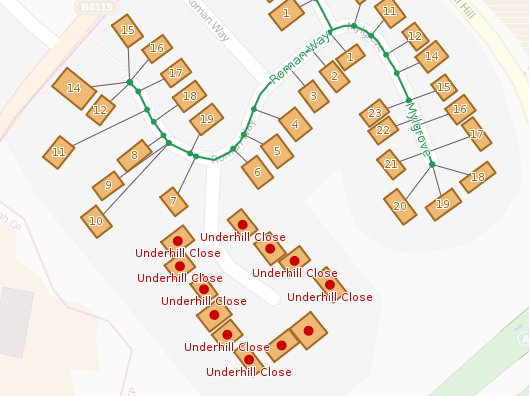
Resolution: The best option here would be to do a ground survey to check for the name on the street, and if you do this you’ll find a sign for Underhill Close. But what if a ground survey is not immediately possible – are there any other sources we can use? Well, we could look at the OS OpenData. I find that OS Musical Chairs is a good site to use. In this case though, the Ordnance Survey don’t have the Underhill Close name (link). Another source is the Land Registry Price Paid data. Using the search form (link), I find this street name in their database.
Example 2: Incorrect street name change
This ones a bit more suitable, but highlights the benefit of mapping residential addresses. In the example the street name changes from Throckmorton Road to St Mary’s Road. I had originally mapped the transition of street name at the intersection with Winchcombe Road (to the north). My adding the addresses it is clear that the transition between street names actually occurs further to the south-east.
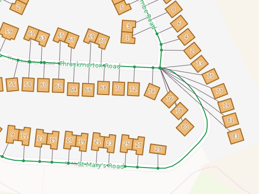
Resolution: In this case we can just change the point at which the street name changes in OpenStreetMap. Somewhere in the south east corner between numbers 83 and 29 will be fine.
EDIT: Why not take a look at what OSM Inspector shows in your neighbourhood.
poppei82
Hi!
Just a hint for using OSMI directly in JOSM (if you use this application): http://wiki.openstreetmap.org/wiki/Quality_Assurance_Tools_script
Additionally you find the tool “housenumbervalidator” included in the next release.
Poppei
davespod
Thanks for that. I had not realised that OSM Inspector had this feature – a long time since I’ve used it. Do you have any thoughts on how to deal with situations where street numbering is related to a group of houses rather than a street? This seems to be common in my village.
For example on the street Stallion Lane, some houses are addressed 1, Stallion Lane, etc. However, there is also a group of houses called Castle Mount. Houses there are addressed 1, Castle Mount, etc. There is no service road that could be named Castle Mount, and the section of road going past the houses is still called Stallion Lane. If I just number these houses and say they are on Stallion Lane, routing software will think 1, Castle Mount, is 1, Stallion Lane. Scratching my head on how to make this work. Have you come across similar situations?