February Mappa-Mercia meetup

posted in: Mapping Party | 2

Our February meetup  took place in a new venue – the Crown Inn on Newton Street opposite the Crown Court. The beer and the food are cheaper (especially the BOGOF* on desserts) and no less good and there’s more room. The only drawback is there’s no wifi. It’s also closer to the main rail stations. So it’s our new permanent venue until we go visiting around the region again from May onwards to take advantage of the light evenings and surveying time.

We had a good turnout of seven: Steve and Ian from Worcesterhire; Pete from Warwickshire and the old regulars – Mike, Brian, Andy and Andrew.

What most exercised us was the remapping  effort, with our region being particularly troubled by one local contributor who had been a keen mapper and is unlikely to agree to the new CTs. Coventry and the Malverns were two particularly hard hit areas. Another was Kingswinford, where there had been no response from the mapper involved. We felt we would be in good shape by April 1st as most of the motorways, trunk , primary and secondary roads were now clean.

We will pay special attention to Warwickshire where Pete informed us about the plans the County Council has to use OpenStreetMap.  More about that when it’s fully live and public.  Pete was keen to see if there was a means by which map features generated in OpenLayers could be edited into OSM automatically.

There were different opinions about the sprouting of a continuous stream of “HS2” text strings  along the route of the proposed HS2 London-Birmingham High Speed Train route on the main Mapnik render.  It was a good indicator of where the route went without examining the layer which had the detailed  layout of the proposed route; but it was not good cartographic style to have the name of a proposed feature which is still at least 15 years away from completion cluttering up today’s map. This raised a more general point with Mapnik rendering names of all kinds of features not present on the ground which clutter up the map (e.g. Parish and Ward boundaries in urban areas).

We all decided to participate, even if it was only for a few hours, in the Night of the living Maps on February 7th. Those of you who couldn’t attend at the Crown Inn are encouraged to join in.  Hope we don’t get too many editing clashes

Andrew wanted people to know about a grant initiative for the developing world, details of which can be found here http://api.ids.ac.uk/about/grants.shtml Andrew had found it on the open data development mailing list which gives all the background. Deadline 13th February, but they have said there will more grants like this in future.

Andrew is still travelling around Warwickshire mapping and cataloguing allotments so we can build on the West Midlands data set which is mapped (roughly!) here as part of our collaboration with http://allotmentdata.org/

Steve had been busy mapping the Parishes in Worcestershire and has kindly provided the data in a usable form for us to complete the West Midlands. We shall get cracking in earnest on this once the remapping is under control, although we’re a little hesitant about “name clutter” – see above.

We discussed what to do with the FOI request which had revealed the Marketing Birmingham ( a public organisation) had spent  over £80,000 drawing a map from aerial imagery, where with a little collaboration with us, would have cost a mere fraction of that.

We still haven’t had a reply from Centro about the City Centre reconfiguration of bus stops and road direction changes to make way for the proposed Metro extension. Work has started already on the ground reconfiguring Moor Street Queensway. Andy said he would add the proposed Metro route extension to the map.

We went through our change register to see what needed updating.  We also discussed how to improve it to make it more usable, by having links to the map for each change; and by eventually having every piece of brownfield land logged.

We didn’t get round to discussing the Jewellery Quarter tourist walking route which Andy M had pointed out was missing by email and for which there was some dispute as to whether it’s actually waymarked on the ground. Even though several of us have surveyed the area no-one could remember distinctly seeing waymarks but then we probably weren’t looking for them! Sorry Andy!

We now have an up to date list of all the taxi ranks from Birmingham City Council which will be a great aid in future surveys and also to jog some memories about past surveys. Expect to see more taxi ranks soon on the map.

We looked nostalgically at the paper map Andy produced in December 2009 to celebrate what we thought was a complete map of the area inside the M6-M5-M42 motorway ring. Complete? How wrong we were!  But as we looked at the map on the table and reminisced that all the roads (except the motorways) had been surveyed by bicycle or foot with GPS devices with no aerial imagery to help us, we realised what a great achievement it was. So …. we thought what a great idea it would be to produce another paper map for December 2012 if we could raise enough funds, particularly as we think we might have every building mapped within the Birmingham City Council borders mapped by then. If anyone wants, for historical purposes, a copy of  the 2009 map, contact Blackadder.

*for non-UK readers BOGOF  Buy One Get One Free

West Midlands Allotments

posted in: Participate, Use The Map | 3

After a steep learning curve with Maperitive and OpenLayers there’s a map of allotments in the West Midlands available here. It’s still rough around the edges but it forms the basis for further development (such as pop-ups with more data). I only really cracked the techniques involved when I discovered Ed Loach’s wiki page. Thanks Ed! I hope people find it useful.

The map is restricted to the West Midlands  because we wanted to work with a data set that was almost 100% complete. The data comes from web pages listing allotment sites published by the 7 local authorities in the West Midlands (Dudley,  Sandwell,  Walsall,  Wolverhampton,  Birmingham, Solihull,  Coventry).  We didn’t hit 100% as there were 14 allotment sites that either couldn’t be located or had other data quality issues. They are listed on a mappa-mercia wiki page and any help in resolving the issues listed would be welcome.  A word of praise here for Birmingham City Council who were able to answer a question about the location of a very small  3 plot redundant site which was at the back of some houses  within 2 minutes of contacting their call centre – very impressive.

It was interesting to see the diversity of how to present the information. The list of facilities available showed the most variation. Solihull was the most comprehensive : Site representative – Y/N; Car park –Y/N; Water – Y/N; Rubbish collection – Monthly from February to November; Green waste delivery – Yes at request of site representative; Security lock – Key (£10.00 deposit required). Solihull was also the only authority to have opened a new site and re-opened a semi-derelict one

Whilst editing the allotment sites, aerial imagery also showed up other sites which are privately-run and not run by a local Authority, so our map and underlying dataset shows a more accurate picture that what can be gained just from local authority listings. Even now we might not have located all the privately-owned and run sites – any help or information will be greatly appreciated.

Sadly we were not able to gather via this route the information we set out to obtain for the Allotment Data project which was waiting list data. Local Authorities do not generally hold this data:  this is maintained by each allotment site association. This will require either a concerted phone campaign or volunteered information  as and when (and if) people see value in this map.

As a result of this work, we discovered the work being done by the New Optimists Forum on food security, and inspired similar work to complete allotment data for Warwickshire. Keep going Andrew!

Mapping data on a themed basis like this opens up all kinds of interesting and linked information and also helps to make contacts and connections with owners and users of the data. Highly recommended for online community building!

Birmingham prepares for winter

posted in: Observations | 0

This statue can be found in the heart of the Bullring retail complex right in front of the Rotunda. I was tempted to tag it with woolly_jumper=yes!

For those of you reading this from outside the UK who think the English are kind to animals I bet you didn’t think we were kind even to statues of animals.

Birmingham’s Custard Factory

posted in: Observations | 0

If this statement is true, and I believe it is, then an OSM map of a city  is meta-art!

This sign adorns the Custard Factory in Digbeth, close to the City Centre; now a thriving arts and media hub with many small businesses located there. As the name suggests it was originally home to Birds Custard manufacture.

Heart of England Way completely mapped!

posted in: Map Improvements, Use The Map | 2

On Sunday I completed a short 4Km stretch around Blockley, the last remaining gap in the OSM map.  Thanks are due to everyone who contributed over the years, collaborating in mapping this long distance route.

The Heart of England Way stretches for some 100 miles through England’s Midlands. This route proves that the Midlands does not justify its image of an industrial wasteland. The Way starts in Staffordshire’s heathlands and forest on Cannock Chase and passes through the small city of Lichfield with its three-spired cathedral known as the “Mother of the Midlands”. It then passes between the industrial giants of Coventry and Birmingham, although with  the peaceful countryside it chooses, you wouldn’t know they were there.  Rural Warwickshire beckons as the Way meanders through the remains of the Forest of Arden. The final part sees it sharing much of its route with the Monarch’s Way as it leapfrogs from one cosy Cotswold village to another. It finally ends up in the tourist honey-pot of Bourton-on-the-Water, where it links with the Cotswold Way.

The most popular Guide to the Way by Richard Sale  has the route going the other way, but describing it this way  reflects more the order in which we mapped it.

Official website here
Best map is of course Lonvia’s Hiking map

Architectural Heritage in Edgbaston

posted in: Observations | 0

It seems that just about every other house in Edgbaston is listed!
(for non-UK readers a listed building is deemed to be of architectural or historic merit and there are strict planning rules as to what you are allowed and not allowed to do in altering and maintaining it).

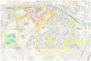
As you can see from the map below it’s a historic part of Birmingham, mostly where the old industrialists lived and thanks to the Calthorpe Estate and the proclivities of said nineteenth century industrialists there weren’t many factories or pubs or cheap back-to-back housing built there (all the yellow buildings are listed)

A few  examples of listed buildings in the area:

As you can see it’s not a cheap area of Birmingham to live in, even today.

August Midland Mappers Meet

posted in: Mapping Party | 0

After some mapping activity in the area of Smethwick which is to the North West  of Birmingham we ended up in the excellent little pub The Black Eagle on the aptly named Factory Road. The pub is like a country pub complete with garden and serves great food and real ale, including the famed Black Country brew Batham’s Bitter. It was so good we’re meeting there next month (nearest metro stop is Soho Benson Road)

We discussed the impact of losing data from people who have not accepted the new CTs; how to recruit new mappers; how to deal with rogue mappers; the possibility arranging some skills transfers sessions and creating a wiki log of all the upcoming re-developments in the region to remind ourselves of future mapping surveys.

The major landmark in the pre-meeting survey of the area was the Soho Foundry created by Matthew Boutlon and James Watt in 1795 which still fronts a large industrial site now operated by Avery Weightronix. The low mark of the evening was the sadly dilapidated Black Patch Park groaning under the weight of fly tippers rubbish.

A Good Read

posted in: Observations | 0

This book, written by a couple of poets takes you to all those places that only mappers have visited repeatedly to lovingly survey and map every detail. Edgelands  addresses all those betwixt-and-between places that aren’t really urban and aren’t really rural and are certainly not loved or cared-for. They’re the kind of places we hurry through to get somewhere else or the kind of places that we just don’t acknowledge exist at all. You know the kind of places: brownfield sites, abandoned parking lots, sewage plants, power plants, abandoned construction sites, out-of-town shopping malls and industrial estates after hours. The poets talk about them reverentially and find a stark and melancholy beauty there.

The bookjacket blurb puts it excellently:

“Edgelands explores a wilderness that is much closer than you think: a debatable zone, neither the city nor the countryside, but a place in-between – so familiar it is never seen for looking. Passed through, negotiated, un-named, ignored, the edgelands have become the great wild places on our doorsteps, places so difficult to acknowledge they barely exist”.

But us mappers have been there and struggled with all their idiosyncrasies and even dynamism as they change use,  in our quest to leave no white space on the map.  Enjoy a different perspective of these places.

ISBN 978-0224-08902-9 published by Jonathan Cape

Going Going Gone!

posted in: Observations | 0

Stephenson Tower, a block of council flats built in the 1960s adjacent to New Street Station is currently under demolition brick by brick. The demolition method and the cocoon is to prevent  dust and protect signalling equipment and the telephone exchange in Hill Street. The demolition is part of the renovation of New Street station due for completion in 2015. More details from the project here.

Tolkien’s Two Towers

posted in: Observations | 0

These two towers – Perrotts Folly and the Edgbaston Waterworks Tower – are prominent landmarks about 600 metres apart in the Ladywood area of Birmingham. As a child, Tolkien lived in numerous addresses in Ladywood and it is reputed locally that these towers are the basis of the ‘Two Towers of Gondor’ – Minas Morgul and Minas Tirith.

This is Perrott’s Folly (above), built in 1758 by John Perrott. No-one knows for sure why he built the tower so it’s called a folly. It was used as a weather recording station from 1884 to 1979.

This is the tower at Edgbaston Water Works, built in 1870. Although the Water Works is adjacent to a large reservoir , there is no connection – Edgbaston Reservoir was built to supply water to the canal system not the domestic supply.