An obscure saint in Yardley

posted in: Map Improvements, Observations | 1

Yardley Old Village is a haven of rural peace set in the middle of the suburban expanse of East Birmingham. There is a cluster of listed buildings around the mediaeval church of St Edburgha, which includes an old farm and a working blacksmith. The church is currently swathed in scaffolding so no picture I’m afraid.

St Edburgha ( pronounced edburra) was grand-daughter to King Alfred and her relics are in Pershore Abbey whose full name is  the Abbey Church of Holy Cross with St Edburgha. I’m not sure if there are any other churches dedicated to her.

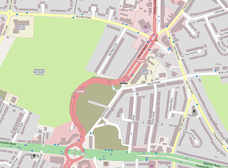
On the way there I surveyed  the new route of the A4040 Church Road, opened this week to accommodate the controversial development of a new Tesco store. The road still awaits a roundabout at its northern end, so the bus route relations haven’t been updated yet. Let’s see how long it takes other map-makers to update this stretch of road.

Ladywood Circus – a "big top" of traffic lights

posted in: Map Improvements, Observations | 0

I drove though here one night and got very confused with the new northbound carriageway going right through the middle of what used to be a roundabout, so I decided to do a survey.  The results are shown below. Is this a record for the number of sets of traffic lights you can fit onto one roundabout? (9 sets and 2 sets of toucan crossing lights!)

Needless to say I couldn’t waste the opportunity so I surveyed some adjoining streets also. I came across what has to be one of the longest  and most evocative church names I’ve ever seen. I don’t know the origins of this church, but I expect it to have been interesting. Has anyone else come across one of these churches?

I also discovered a small patch of rural delight nearby – what a great way to enliven an otherwise patch of waste ground and make our urban life brighter. Congratulations to whoever is responsible. It’s not a great photo but there’s a sea of white daisies awash with poppies.

Interesting wanders around the Jewellery Quarter

posted in: Observations | 0

I’m gradually surveying the Jewellery Quarter by default , as I work through the City Council’s database of listed buildings. It’s a fascinating journey of urban renewal. Its a very mixed area, with lots of apartment conversions – some architecturally tasteful, some just an eyesore of erected building materials; lots of hip small knowledge and professional companies and their feeding stations of equally hip restaurants, bars and cafés; masses of jewellery workshops and shops and  the odd bit of good old Brum metal-bashing, together with some very derelict parts looking very forlorn.  Mix in stalled building developments, casualties of the credit crunch and you’ve got a mapper’s heaven and probably an urban planner’s hell!  Here are some of the best listed buildings I found, along with some falling into decay.

Tenby Street North
Tenby Street North
Legge Lane - a general area of dereliction
Legge Lane – a general area of dereliction
Corner of Regent Street and Vittoria Street

Recognition at last!

posted in: Mapping Party, Participate | 0

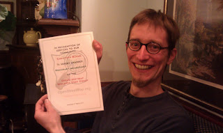
Many thanks to Christoph (OSM username Xoff) on his departure to Germany after completing his PhD. Christoph performed sterling surveying work over much of SW Birmingham and also contributed a huge technical resource in developing our website mappa-mercia.org and creating NOVAM for verifying NaPTAN bus stops. Good luck in you future career Christoph!

New Street Station

posted in: Observations | 0

New Street station is not one of the loveliest travel destinations on the the planet. There is currently a massive refurbishment programme underway scheduled to finish in 2015. So just to get ahead of the game in mapping the new layout – here’s a view of what it will look like.  I just hope they’re not going to spray-paint all the buildings this awful  beige colour! For more information you can visit www.newstreetnewstart.co.uk

Centre of England

posted in: Observations | 2

Mopping up and correcting road names in the rural wilds of Solihull saw me in Meriden where I came across an ancient memorial cross reputed to mark the centre of England. I know it’s a complex mathematical problem but has anyone ever located the precise point that is the centre of England? Perhaps it would be better not to know as it spoils the folklore!

Whats in a Postcode?

posted in: Map Improvements, Participate | 5

Andy has been busy in B72, the heart of Sutton Coldfield, so exactly what does this mean for our map?

Short answer:
Nearly 3500 residential properties,
Almost 300 named retail units,
Nearly 100 commercial buildings,
All drawn in and with full address details including the full postcode!

Long answer:
Its taken a little over two months, a half hour here and there out walking and cycling the streets to collect all the address data; house numbers, retail names etc. Many more hours at the computer drawing each of nearly 4000 seperate buildings and in the case of residential properties their associated gardens.

This means that B72 is essentially fully mapped out. Nearly 50,000 objects in all (nodes, ways and relations). Of course we could find more to map even now but the current result is as detailed and rich a dataset/map as almost anyone should ever require.

You can browse the map here or search out an address in B72 using nominatim.

Lessons learnt:
In undertaking an exercise such as this there are always lessons to be learnt. Here’s just a few that may help and spur on others to map their areas in full detail.

  1. Tools that orthogonalise buildings (hit “Q” in JOSM or Potlatch2) are a godsend, also the duplicate and node merge (“M”) facilities when it comes to creating multiple buildings of the same shape and size.
  2. Most traditional retail units have a front facing length of 20 feet (6.1m). Very handy when dividing up long runs of shops.
  3. Postcodes were added using the OS OpenData CodePoint dataset. Postcodes are unique to a particular street (or in some cases particular address) with postcode changes along a street normally occurring at a connecting side street or other natural break (public footpath perhaps). In a handful of cases its impossible to know if a building opposite a side street is in one postcode or another and in these few instances the postcode has been left as a “?” until it can be verified.
  4. When looking at all the property boundaries you find a number of other features that are easily overlooked. Local electric substations being a good example.
  5. There is no easy way to deal with properties with vertically mixed use. For example flats over shops. A longer term solution is needed for these.
  6. Property addresses in private gated roads are difficult to obtain unless you are granted access.
  7. To show all business names in the retail heart of a town or city you really need an extra zoom level (z19) or a method of better dealing with icon and name conflicts on the rendered map.

So what’s next, well of course B72 is just one small area containing just 242 unique postcodes. Birmingham postal region alone has nearly 42,000 unique postcodes so there is a huge amount to do even for our local mapping group and without more help it will take many years. Please help by joining the project, every property and address you add to the OpenStreetMap project means more information available to West Midlands individuals, organisations and businesses.

More: Mappa-Mercia OpenStreetMap user group
Contact us: info (at) mappa-mercia.org
Radio Coverage for Gritting Map

posted in: Participate, Use The Map | 0

Today Brian appeared on the Ed Doolan Show on Radio WM to be interviewed about our Gritting Map. Good to get some publicity. There is a recording of the interview courtesy of Russ Philips but the blog technology won’t allow upload of audio files (or I don’t know how to do it). So if you want to listen email the community contact or press contact at the mappa-mercia website. Solihull MBC contacted us with this year’s amendments to gritting routes so that we can update the map, along with their thanks for our public service. Birmingham City Council had done likewise earlier. Walsall’s data is now on our map and within the next few days Wolverhampton should be complete

Let’s hope Sandwell and Dudley release their data soon.

Break out from my urban surroundings

posted in: Map Improvements, Observations | 0

Sometimes I feel the urge to break out from my urban conurbation surroundings and map somewhere all together more rural. I don’t get much time these days to map so it was a real pleasure to head out in the autumn sunshine yesterday on the bike. The destinations I picked were Colwich and Little Hayward which are located between Stafford and Rugeley and were essentially blank on the map save for the A51, the railway lines, canal and the river Trent, all of which run parallel through the area.

One of the things I really enjoy about mapping for OSM are those things that you would never see or learn about (and which you can add to the map) if it were not for getting out there on the ground. Yesterday was no exception but unlike the usual notable place of interest, interesting feature or great view it was a moment to reflect, for I stumbled upon a tiny beautifully tended memorial garden, easily missed and tucked away at the specific spot of a tragic event in 1986, the Colwich Rail Crash, something I really had no knowledge of previously. The garden is now a memorial to two men, Eric Goode the train driver who tragically died in the crash, and Alf Taylor, a retired railwayman who created and tended the garden until his death in 1997. OpenStreetMap gives us the opportunity to place important places in our landscape like this clearly on the map, something I’m always pleased to be able to do. Should you wish to find it yourself it’s here.

New Queen Elizabeth Hospital Opened

posted in: Map Improvements | 1


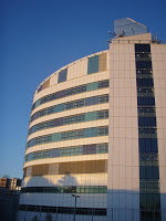
The three white cylinders of the new hospital have already become familiar sight in Selly Oak but it was only today that the new Queen Elizabeth Hospital finally opened. At the same time the barriers which were blocking of major parts of the new road network for accessing the University and the new hospital site disappeared as well offering a great opportunity to map some pristine roads!

 
So, when I cycled home today I switched my GPS receiver on and made a small detour; the results can be seen on the map.