A exercise in micro-mapping: The National Memorial Arboretum

posted in: Map Improvements, Mapping Party | 1

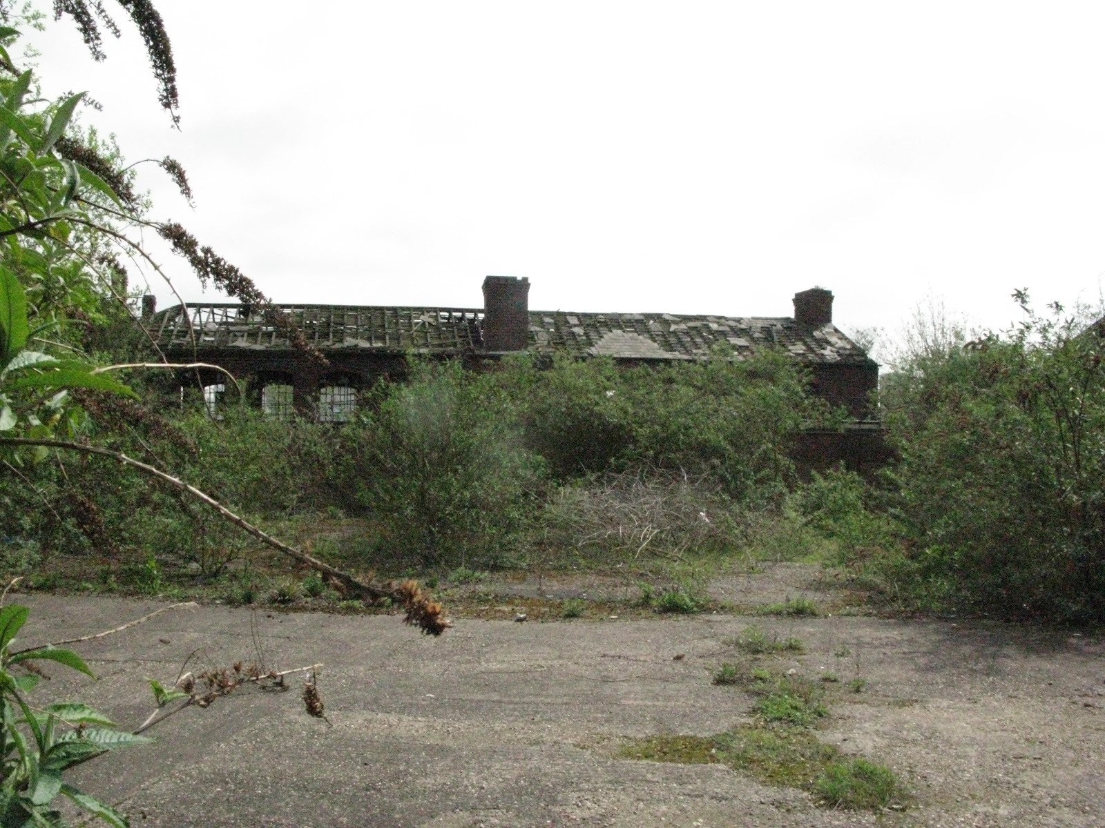
The National Memorial Arboretum had been nagging at us for months, being a cultural resource of national significance situated within  our mapping “domain”, and having only the sketchiest of coverage in OSM (thanks to those who had got it to at least that level). So one evening in the pub we decided to tackle mapping its 150 acres (0.405 ha).

The National Memorial Arboretum sits on a piece of reclaimed gravel pit alongside the River Tame. Inaugurated in 1997, it was designed to rival the Arlington National Cemetery in Washington DC. Its obvious military bias is now being somewhat softened by the appearance of  memorials to any event – for instance there is a grove of trees where those reaching their diamond wedding anniversary (60 years) can plant a tree and have it dedicated to them.

Given the horrendously wet summer Britain has been experiencing, the three day survey carried out by mappa-mercia volunteers (all of two of us) spread out over a couple of weeks was a squelchy affair – a reclaimed gravel pit adjacent to a river has a pretty high water table!

There are over 200 memorials ranging from the simplest plaque; large gardens; benches; flagpoles; ornate sculptures on plinths; relics from battlefields and campaigns (for example pieces of the Burma Railway from WWII) to the elaborate centrepiece of the Armed Forces Memorial. And of course the 50,000 trees which are either arranged into named groves or are individually dedicated.

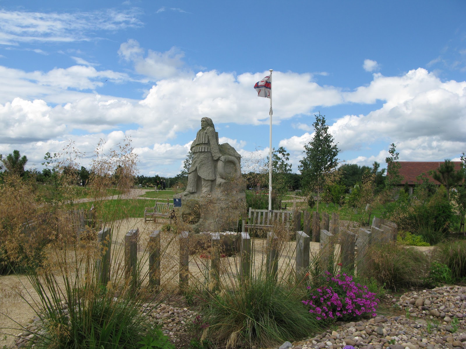
Here’s an example of a memorial – this one is for the Royal National Lifeboat Institution which has benches, a sculpture,pathways and a flagpole all contained within a garden designed to recreate the feel of a shingle beach:

We concentrated on the memorials, gardens and groves and we think we’ve got about 95% of them. The hundreds of benches and trees that have individual dedications overwhelmed us and will take someone more dedicated than us several months of surveying.  Of course memorials are being constructed constantly so periodic resurveys will be necessary. The day after our final survey a new memorial to the Parachute Regiment was due to be dedicated and there were feverish preparations underway for the ceremony.

In any case a resurvey will be required as the Visitor Centre is due to be expanded (reconstructed would be a better description judging by the plans on display) to cope with the visitor numbers- currently at 300,000 annually. Many visitors are grieving comrades or relatives, and there are of course the regular annual anniversary ceremonies by many veterans’ associations and military units; but as the site is such a fantastic educational resource for British history I guess it attracts many school visits also.

The problem with micro-surveying at this level was that the POIs to be recorded (memorials,benches,trees, flagpoles etc) were often closer together than the accuracy of our GPS units (sub 5 metre), so that interpreting GPS data could only take place with the help of a huge number of photographs to show proximity and orientation.  So the usual rule of thumb that one hour of surveying translates to one hour of editing  became more like 2- 3 hours of editing as GPS traces, notes and photos all had to be cross-referenced for accurate placement. Also most names of memorials were long and complex and needed careful attention to spelling.

The resulting map can be viewed here. As can be seen the current default rendering has problems with so many names being so close together that it’s difficult to display them all. Anybody want to have a go at solving this? Is it soluble?

There remains one other major mapping problem. The National Memorial Arboretum is part of the National Forest : an ambitious project to plant 200 square miles of central England with trees to recreate the original forested landscape. 7.8 million trees have already been planted and the tree cover increased from 6% to 18%.  How to map this? It’s not a national park. It’s not contiguous, but a patchwork. It’s not all forest but has open spaces also. Most of the tree-planting is not mature. It’s run by a private company created by Act of Parliament under the auspices of a government department DEFRA (Department for the Environment Food and Rural Affairs) – so is it leisure=park? Should its whole outline be mapped and named as a region with a ceremonial administrative boundary? Should the planted areas be mapped as a multipolygon and added to as new areas are acquired and planted? How should the constituent parts be named: as National Forest from the multipolygon, or for each area where it has a separate name? Any comments are welcome.

Next national resource in our region to tackle: the recently-opened National Football Centre at St George’s Park near Burton-on-Trent.

All Change for Birmingham City Centre Buses

posted in: Map Improvements, Participate | 3

A mapper’s job is never finished! For those of you who might think that the UK and Western Europe are pretty much complete and we don’t have much to do – there’s ALWAYS something changing somewhere.

Today, Sunday 22 July, is the culmination of several months of planning and roadworks to complete a major reconfiguration of Birmingham City Centre’s  bus stops which bans buses from the City Centre, grouping bus stops into 5 separate Interchanges on the periphery of the business/retail downtown area.

This has been done firstly to improve traffic flow on the bus network and secondly to free up streets for a Metro line extension from Snow Hill railway station to New Street railway station (so more changes for us later)

We’re proud to say that we have completed mapping and editing 80% of the changes today. ALL the physical changes have been surveyed, mapped and edited: what’s holding us back is untangling and re-routing the relations for bus routes. Another example of the combination of dedicated local mappers, OpenStreetMap and the editing tools at our disposal, being unbeatable!

The 2 organisations responsible, Network West Midlands and Centro, have published very good information and their staff have been very co-operative. Birmingham was blanketed with their staff today, helping out hapless passengers, who despite a week of blitz publicity, were still very confused. We made contact with the staff responsible for the data, swapping information about  our queries from ground surveys. We also got from them a rough timetable for the rollout of some additional, new bus stops. Hopefully we can build on this contact and keep up to date with future changes.

To get a feel for the surveying/mapping/editing effort:

  • 24 bus stops removed/deleted
  • 10 new bus stops added
  • 126 bus stops changed name
  • 5 new bus-only road links built
  • 1 dual carriageway reversed
  • 1 new car park access road added
  • 2 taxi ranks moved/removed
  • 3 streets reversed oneway direction
  • 3 streets pedestrianised
  • 89 bus route relations checked/revised

If you want the official version of the changes go to http://www.connectedcity.org.uk/

40 year old spaghetti

posted in: Observations | 1

Spaghetti Junction is 40 years old this month; having opened for traffic in May 1972. Its official name is  Gravelly Hill Interchange and forms J6 of the M6 where it meets the Aston Expressway. The name of Spaghetti Junction was coined by Roy Smith, a journalist on the local newspaper; and it is still  the name by which it is known, much to the annoyance of officialdom.

Now to many people in the world a junction of this scale and complexity is no big deal, but in 1972 it was an engineering,  social and transport wonder to the population of Britain. After opening it was soon carrying 40,000 vehicles a day. Today it carries 5 times that volume of traffic and is subject to regular maintenance and strengthening to keep pace with the traffic flows.

It took 4 years to build  the  30 acres (12 ha) junction, which serves 18 routes by means of 4 km (2.5 mi) of slip roads. Interestingly the junction contains only 1 km (0.62 mi) of the M6 itself. Just to add to the complexity of the engineering task the junction sits atop of 2 railways, three canals and two rivers. The solution required 5 different levels, 559 concrete columns, reaching up to 24.4 m (80 ft) and a 21.7 km (13.5 mi) elevated section of motorway.

It was similarly difficult to map it for OSM, so congratulations to the pioneer mappers who had this junction mapped in the very early days of OSM when there was not much more on the map of the UK than the coast and the motorways.

The Aston Expressway (designation A38(M)) is also a transport oddity, being the only single carriageway motorway in Britain. It consists of 7 lanes and operates a tidal flow into and out of the city: more lanes into Birmingham in the morning and more lanes out in the evening. It is also odd amongst UK motorways in having a maximum speed limit of 50 mph.

According to the Guardian newspaper, a poll of drivers nominated Spaghetti Junction as the most terrifying junction in the country, with many drivers opting for diversions of many miles in order to avoid it.

To celebrate the anniversary Dunlop, the tyre manufacturer, based at nearby Fort Dunlop where it manufactures tyres for motor-sport, organised a ten truck convoy to converge on the junction from different routes for an aerial photograph marketing shot. Dunlop reckon they have shipped over 10 million tyres across the junction since it opened.

More canals than Venice?

posted in: Observations | 8

“More Canals than Venice” is something you’ll hear often in Birmingham or from Brummies anywhere, to describe the city. It’s mostly a defensive mechanism, I believe, because Birmingham does not enjoy the best of reputations in the nation’s affections and is  the butt of many a joke. It’s repeated incessantly,  completely oblivious of perhaps better claims from cities like St Petersburg or Amsterdam, which have the added advantage of being much higher in the tourist destination stakes than Birmingham. (Though curiously one of the few boom sectors in Birmingham is hotel construction, with increasing numbers of visitors filling the rooms once they’re completed.)

Perhaps those with the database skills could analyse the OSM data and settle the argument once and for all – which city does have the most canals?

However Birmingham does have one unique claim to fame: a canal roundabout at the junction of the Birmingham and Fazeley Canal and the Birmingham Canal Navigations. And yes, it is tagged with junction=roundabout, although I don’t know whether the direction is correct as I’m not a boat navigator and don’t understand the “rules of the road” for boats. There are certainly no oneway signs present. And I’ve never been present when boats are going round it so I haven’t seen which direction they take.

Birmingham’s canals were built for commercial heavy-lifting during the Industrial Revolution and until fairly recently were woefully neglected. There are still large stretches which pass through industrial areas which can be pretty grim waste-strewn and graffiti-heavy thoroughfares. In contrast, around the City Centre there have been lots of developments of waterside apartments and cafés and nightspots using the canals as an attraction. You have to understand Birmingham is one of the few cities in the world not sited on  a major river so water has a special attraction for the city’s inhabitants and visitors. We even have a waterbus which plies the short distance from the Mailbox (an upmarket shopping mall) to the NIA (National Indoor Arena – a major indoor sports and event venue). It’s mainly used by tourists: locals find it quicker and cheaper to walk.

It makes a strange journey to cross the city via its canals, avoiding the traffic and not being aware of the usual landmarks. All your usual mental landscape of knowing where you are evaporates and you look at the city in a new way. On the subject of avoiding traffic, the canal towpaths make excellent cycle routes and are used regularly by the city’s cyclists.

If you visit Birmingham, take half an hour to descend from its streets to wander along its canals – you’ll come away with a  much better impression of the city – not comparable perhaps to Venice, but better than when you arrived.

Birmingham: the less glamorous side

posted in: Observations | 0

Regular readers of this blog might have the impression that Birmingham is filled with splendidly maintained examples of architectural heritage, as I try to liven up mapping on the ground by centering surveying trips around them. Nothing could be further from the truth!

Owning a listed building is an onerous (i.e  expensive) undertaking. Whilst wealthy businesses and individuals, and large state institutions can enjoy the prestige that occupying such buildings confers upon them, for others it’s more of a struggle. Often the National Trust or English Heritage have to step in and rescue buildings that are in peril. But their budgets are not limitless so few can be rescued in this way. Birmingham Civic Society also does its best to preserve listed buildings that are in danger within the City, but with even more limited funds.

Not only are owners restricted on how they can adapt and extend their buildings, in order to maintain their architectural integrity, but they are often restricted to using original materials. Original materials are rare or non-existent and have to be specially manufactured, sourcing both of which is expensive. Then craftsmen skilled in using such materials have to be found and hired, again at premium rates. All this makes the planning process even longer and more complicated than usual, adding to project timelines and costs.

It’s not surprising then that some owners just give up and let these building slide into decay, as some of these pictures show. The building covered in scaffolding is to prevent it collapsing, not an indication it’s being refurbished. The buildings shown here are all within a 5 minute walk within the Jewellery Quarter, which las led to a whole area becoming blighted as far as development is concerned. (Generally the Jewellery Quarter’s large and varied population of listed buildings is very well-maintained and has been the subject of previous blogs). Trying to persuade developers to enter such areas is yet another headache suffered by City Council planners.

The cynical amongst us might well suggest that the owners are hoping that the building eventually has to be demolished purely for safety reasons, which then gives them a free hand to develop the site.

Surveillance gone mad?

posted in: Observations | 3

Can anyone beat this for density of surveillance cameras?  I know we live in a security-conscious world but I think this is a bit excessive. Spotted on Broad Street in Birmingham between the Hyatt Hotel and Symphony Hall. Or maybe there is a technical reason for this configuration? They seem to me, as a non-expert, on cursory examination to be capable of  horizontal 360 degree rotation.

Has anyone noticed the growth of ANPR (Automatic Number Plate Recognition) cameras at the exit of many motorway service stations?

Whilst on the subject of ANPR cameras, there was a major national news story last year about a blanket installation of ANPR cameras in the mainly Muslim areas of Birmingham, financed by a counter-terrorism budget and erected without local consultation. After a short and controversial political battle they were removed.

Now they seem to be sprouting up on many trunk roads and major routes into and out of Birmingham, so that the entire city is covered. Has anyone else noticed them? Are they sprouting up in other cities? I think there has long been a ring of such cameras around the City of London (the financial district)

May 2012 meetup

posted in: Mapping Party | 0

Thursday May 3 saw us on the first of our summer itinerant meetings where we strike out from our regular winter quarters of a regular pub in Birmingham, and go touring around the region. This has two benefits: it gets us taking advantage of the light evenings to go mapping for about an hour prior to our meeting and thereby improving some neglected areas, and it gets us closer to those mappers who find it inconvenient to get to the centre of Birmingham.

So we met up in the White Lion Inn in the little village of Hampton-In-Arden in Solihull close to Birmingham International Airport and Train station and roughly halfway between Birmingham and Coventry. We had picked the pub at random and it turned out to be great, with good food and real ales. It’s a 17th century inn and is a Listed Building.

The weather was foul so not much mapping got done, but we did get to meet some new people: Eike from Tamworth (tamritt) and Matt from Coventry (milliams). It was nice to meet people whose work you keep seeing as you edit.

Perhaps the most interesting mapping “discovery” was a Coptic Orthodox church – one of only 12 in the whole country.

The conversation, as usual, ranged far and wide over all things mapping. We did come to a couple of decisions, however: we’re going to revamp the mappa mercia website and also to hold a small “hack” event, hopefully in conjunction with the local social media activists.

For those of you who picture Solihull as an affluent suburb of Birmingham famous only as the place where the world’s Land Rovers are manufactured and are surprised it has country villages: Solihull stretches between Birmingham and Coventry and some way south into Warwickshire and is probably as rural as it is urban – hence its official motto Urbs in Rure (Town in Country).

See you in Coventry next month! Watch the mappa mercia OSM wiki page for details of venue.

What lies beneath?

I know we have enough on our hands with mapping what we can see: but what about what’s under our feet (or wheels)?

On my travels around the West Midlands countryside I regularly come across pipeline markers like the one illustrated. Depending on my route I can often join up the markers to trace the corresponding  underground pipeline. The oil pipelines carry a  lot of information as you can see which is why they get photographed.

They are a lot less common than the gas pipeline markers which are a boring white pipe about 2.5m high with a fluorescent orange top. These carry a lot less information just usually who you can ring in an emergency. Some have serial numbers but  by no means all. Where one can be seen in the distance but can’t be reached because there are no rights of way to it , the fluorescent marker allows a compass bearing to be taken and a distance estimated for later editing against Bing imagery.

Some pipeline markers have bright fluorescent roofs on them making them look like an arrow pointing skywards. They are numbered and are apparently designed for locating by aerial imagery, although I’ve yet to be able to discern one at Bing’s resolution.

The West Midlands has several oil pipelines crossing it, with at least 4 large oil terminals: BHX Airport; Kingsbury; Fort Dunlop; and Bedworth in our region so we get to see a lot of pipeline markers.

Linewatch runs an excellent website with information to help in preventing builders and civil engineers digging up and damaging pipelines. The page here has a great collection of pictures of what the different companies’ markers look like. In urban locations they can be  much more unobtrusive and consist of brass plaques mounted in the pavements. I’ve hunted for them around the Fort Dunlop terminal but without success so far. It might make a good treasure-hunt type of mapping party! My wife just thinks I’m nuts when I get excited about coming across one of these markers on our walks representing as it does, another piece of the jigsaw puzzle. She is good enough to point out ones that I’ve missed though!

There’s also a good schematic map of where the pipelines go. Very detailed locations, which are copyrighted, can be found  at a related membership site Linesearch, which is off-limits to us OSMers and is really for on-site contractors operating digging equipment.

Birmingham is also the termination point of the Elan Valley Aqueduct, a (largely) buried pipeline bringing  water over 73 miles (118 km) from the Elan Valley reservoir in mid-Wales. Water travels at about 2 miles per hour along the pipeline taking about one and a half days to reach Birmingham at the Frankley reservoirs. It was built over 100 years ago, between 1893 and 1904 and is an engineering marvel, dropping only 52m over a length of 118 km – a gradient of 1:2300. The water arrives by gravity alone with no assistance needed from pumps. Whilst most of it is underground there are stretches of overground pipeline and there are  aqueducts bridged over rivers and the odd brick-built valve house. It was mapped with the aid of out-of-copyright Ordnance Survey maps.

Interestingly there is a large network of state-run pipelines known as GPSS (Government Pipeline and Storage System) largely for supplying military installations and is a hangover from World War II and Operation PLUTO (Pipeline Under the Ocean) prepared for supplying the D-Day landings.

As none of this gets rendered, why should anyone get excited about unseen, underground pipelines. Well, firstly there’s the intellectual satisfaction of working out what all the surface paraphernalia relates to and also of linking it altogether in a network. Secondly there’s a sense of completeness in mapping how energy, water and other industrial requirements traverse the planet. Thirdly if we’re given a tag which shows up in the editors (well it does in JOSM – I haven’t checked in Potlatch) then I suppose we’re duty-bound to use it!

Do other mappers in parts of the world, where land is not at such a premium as it is in the crowded islands of the UK and pipelines can  constructed above ground, map them? If they’re a major landmark shouldn’t they be rendered?

Perhaps the nice folks at ITOWorld will give us a rendered layer of pipelines?

Is there a way of joining the surface links of a pipeline such as reservoirs, terminals, pumping stations, venting stations, refineries, chemical works together in a relation?

Currently I indicate direction of flow with a oneway=yes tag where this can be ascertained from the  above-ground marker, which results in an error message nag from the editor and lots of little arrows rendered that are attached to nothing. So if you see one of these arrows and are wondering what on earth it can be – I’ve been mapping pipelines beneath you.

Musings on the psychogeography of addr:housenumber=13

posted in: Observations | 2

Within the West Midlands we have surveyed and edited many thousands of addresses. It can be tedious work, made more frustrating by a simple error that everyone makes initially. This is recording the first and last house numbers in a row of houses when out surveying and later at home trying to allocate the house numbers to traced building outlines only to realise they don’t fit for odd number ranges. Guess what? Our logical minds assume that odd numbers progress incrementally and that includes the number 13, but the irrational, superstitious mind doesn’t want a house with an “unlucky” number. So many rows of odd-numbered buildings jump from 11 to 15, omitting the number 13.

Now 13 isn’t an unlucky number in all cultures so we wonder if there are other house numbers that are avoided in other countries. Perhaps also there is  variation within cultures where 13 is unlucky with different tolerances to the house number 13 in different countries and regions? And similarly for other “unlucky” numbers?

An added complication to surveying is that avoiding house number 13 is not universal. Victorian and Edwardian houses (c. 1800-1914) have no such inhibitions. The practice seems to have crept in somewhere in the 1940s and 1950s becoming more prevalent so that new housing developments (from around the 1990s) NEVER have a number 13. We can’t be precise about the changeovers because we haven’t done a scientific analysis, so this is just a rough “feel” for the data. Maybe someone, somewhere has done the analysis. If it hasn’t been done – perhaps there’s an opportunity for  an academic research paper.

Also some new owners have “retrofitted” older houses which were numbered 13 as 11A! Again we haven’t analysed whether this is just cosmetic or whether there are legal and administrative processes for the Post Office and local authority to record the change in official databases and legal documents such as title deeds.

It seems that the Victorians and Edwardians  lived in a more rational age, closer to the Enlightenment and more optimistic about scientific and technological progress. A century later with even more scientific and technological progress (think powered flight, atomic power, computers, the Internet, TV, DNA, antibiotics and so on and so forth) and an understanding of the universe several orders of magnitude greater, yet we’ve reverted in a basic social function to a more irrational and superstitious practice.

Perhaps the randomness of survival and death in two World Wars played a part; but contrary to this, earlier generations faced high mortality rates through natural causes: disease.

A mapping blog is probably not the place to solve such puzzles, but we can map the data and leave others to worry about them. Anyway it provides another instance of how mapping can reveal hidden trends which lead into unexpected lines of inquiry.

Is this the most architecturally elaborate substation ever built?

posted in: Observations | 3

To make adding buildings to OSM slightly more interesting, I’ve been targeting listed buildings (for non-UK readers these are legally protected buildings and structures that have historic or architectural significance, with strict rules on alteration and preservation). Obviously the graffiti painters are excepted from these rules!

This gives me some motivation for surveying and provides some welcome relief from what can be a tedious process. Further web and library-based research can also be rewarding.

So imagine my surprise to see a humble electricity substation appearing on the list. Intrigued, I set off for the Selly Oak area of Birmingham and found this gem just off the Bristol Road, behind the library.  Either energy prices were even more of a rip-off when this was built, or architects and engineers were given more scope to exhibit civic pride in their work. I like to think it was the latter.

Has anyone else anything better in the way of ornate electricity substations?