During the cold, wet days of a UK winter it is tempting to contribute to OpenStreetMap via the comfort of your own living room. Unlike when OpenStreetMap started in 2004 this is actually now a reasonable way to contribute to the map – we have high quality aerial imagery (including that from Warwickshire County Council), a licence compatible version of ‘StreetView’ courtesy of Mappillary, and numerous OpenData data sources.
Despite this we do still encourage contributors to get out and map ‘on the ground’. The benefit of an on the ground map survey is that you are always seeing up to date data (what is there now, rather than months/years ago when imagery was recorded) and you get to learn many of the intricacies of the environment around us. It can also really fun!
So how easy is it to be a mapper ‘on the ground’? According to seasoned mapper, keen cyclist, and Potlatch developer, Richard Fairhurst, it’s not easy enough. In this fascinating talk at State of the Map US last weekend Richard makes a plea for OpenStreetMap apps for iPhone and Android. A lot has changed in the last 10 years and OpenStreetMap needs to keep it’s tools up to date whilst continuing to make it easier to contibute to OpenStreetMap.
It’s now May and the project is a month old and with two months to go, it’s time for an update.
Robert Whittaker has an excellent site monitoring OSM data on postboxes in the UK. Here you can see progress (even a league table of who’s contributing). From the history graph you can see there’s been an increase in activity since the project got going. Perhaps Robert might provide some data analysis about the effect of the project.
Enter a postcode and you can find all the missing and incorrect postboxes nearby. I was amazed at just how many were missing in the areas I map regularly: a great incentive to revisit all kinds of places. In doing so I discovered one of those rarities: an EVIIIR royal cypher(OSM node 448635608).
(For non-UK readers King Edward VIII was only on the throne for about 11 months in 1936 before abdicating so there are only about 130 postboxes bearing the royal cypher EVIIIR, these being the ones installed during those 11 months)
How many of these are actually recorded in OSM? It would make a great treasure hunt for the rest of the project. From web research I think there are only 2 in Birmingham so my job’s done.
I’ve been unable to track down some of the indoor postboxes – two in particular are indicated in Sainsbury’s supermarkets near me, but neither exists. This led me to wonder whether Sainsbury’s had some kind of agreement with Royal Mail which didn’t work out so they were removed. But you can’t build a hypothesis on two pieces of data! Does anyone have any knowledge of this? Or replicate my findings?
In the West Midlands we’ve had some fun trying to locate the Coventry ParcelForce depot which is NOT where Google thinks it is. It moved over two years ago and is now mapped in OSM . Thanks must go to our local sleuth: spiffymapper.
Parcel Lockers are poorly mapped – only 8 existed in OSM for the UK at the start of the project. Now there are 11 . It turns out that one of the operators, ByBox, has its national distribution centre in Coventry so time for spiffymapper to get his sleuthing shoes on again!
Any other stories on what folk have been up to on this project are welcome.
Our first attempt at a quarterly project has just finished, where fixing road names was the target. I’m sure there was an uplift in the rate of clearing these up and a big thank you to everyone who took part, but we don’t have any formal metrics (perhaps ITOworld might do some analysis on comparable rates across quarters) and there’s still a way to go to clear the total number of mis-named roads. What is clear is that there’s not enough mappers on the ground to tackle something basic like this and we don’t have a scalable method for contacting existing and potential mappers. I guess maintaining a map isn’t as exciting as creating one! Anyway as we proceed with quarterly projects hopefully we’ll evolve how to solve both problems.
Our goal with quarterly projects is obviously to improve the map in a co-ordinated way but also to try and develop the UK mapping community by reaching out to new audiences and to re-energise existing and lapsed mappers.
So, on to our next project: all things delivery-related
This could be Royal Mail postboxes (still loads to do); Royal Mail delivery offices and sorting offices; delivery areas/gates to factories and town centre shopping malls; maxheights and maxweights on roads; courier depots; distribution warehouses; new internet shopping parcel lockers (see wiki entry); there’s a new parcel-collection service based around mainline stations called Doddle.it; airfreight facilities; railway marshalling yards; secure lorry parks; port/dock facilities and anything else you can think of. All suggestions and stories welcome.
OpenCage Data have featured us in their long-running Open Geo interview series. You can read the interview here.
OpenCage Data is a division of Lokku. Founded in 2006 and based in London, Lokku are long time supporters of OSM – they’ve sponsored numerous State of the Map conferences, mapping parties, and made major donations to HOT-OSM and OSMF’s server drives. They also run #geomob, a meetup of London location based service devs. Opencage are best known for Nestoria, a property search engine.
Have you been following our UK quarterly project to fix road names in OpenStreetMap and been wanting to contribute but don’t know how? If yes, then read on to find out how.
Firstly OpenStreetMap is a volunteer driven project that aims to build a free map of the world. The first 10 years of this project have been extremely successful – our contributors have collected data that is so rich and diverse that OpenStreeetMap now powers map data on hundreds of web sites, mobile apps, and hardware devices. Welcome to our community!
There are two ways to contribute to OpenStreetMap: you can notify the community of something that needs changing, or you can jump in and make the change yourself. Notifying the community is the easiest option but it may take some time for the change to be made. To add a note head over to openstreetmap.org and click “Add a note to the map” (the icon just above the question mark on the right hand side). You will need to drag the pointer to the correct location and type a comment in the text box.
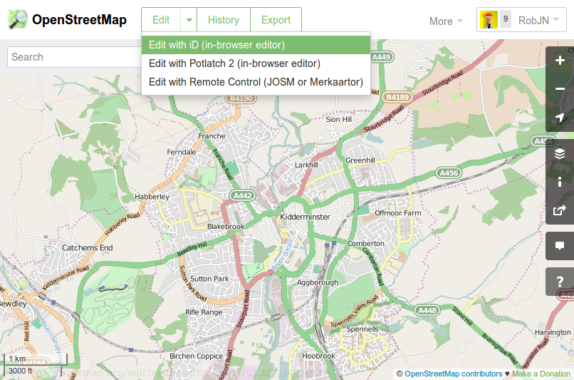
Editing the map data requires a few more steps but the guide below will help you to fix a road name. We will be using the iD map editor but this task can also be accomplished with other map editing software such as Potlatch 2.
To check for incorrect road names in your local town move the map to the area of interest and click the “Edit” drop down arrow, then “Edit with iD”. This opens the iD map editor. If this is the first time you have used iD you will get a walkthrough guide that shows you how to edit OpenStreetMap. This guide can be restarted at any time by pressing “h” to bring up the help menu and then clicking “Start the Walkthrough”.
Opening the iD map editor
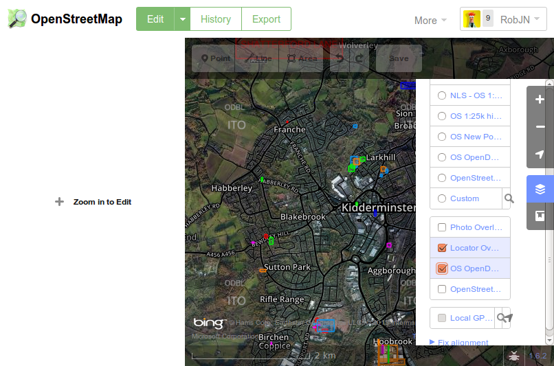
To see which road names need checking in your area click on the background settings icon on the right (or press “b”), then tick “OS OpenData Locator”. This brings up any brightly coloured squares on the map which indicate where the Ordnance Survey has a different road name than that of OpenStreetMap.
Show potential road names that need fixing.
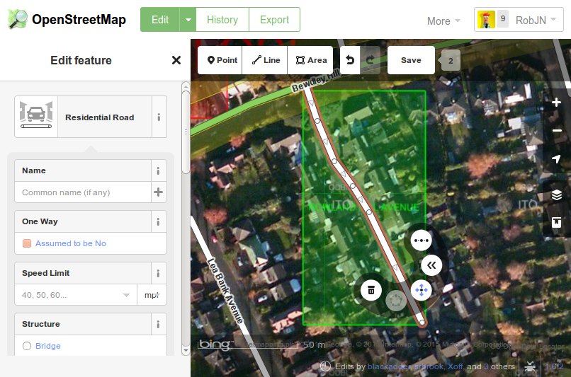
Once you confirmed the correct name (for example, by seeing what the road sign itself says) the you can enter this in OpenStreetMap by clicking on the road and then typing the name into the “Edit Feature” panel that opens on the left. Once finished don’t forget to click “Save”.
Edit the road name.
Congratulations, you are now part of a community of mappers that contribute and maintain data about roads, trails, cafés, railway stations, and much more, all over the world.
Now that Itoworld have resolved their technical problems we can see if the Road Name Quarterly Project is having an effect. Here are the top 20 local authorities from Itoworld’s OSM Analysis service:
Thanks to all the mappers who have participated, including those not in the top 20: if you’ve only got a couple of roads left to check you’ll never appear in the top 20 but your contribution is just as valuable.
Congratulations also to those who’ve got their local authority area to the 100% mark recently: Torfaen; Dover; Gwynedd; Powys; West Lothian; Wolverhampton; and South Gloucestershire.
It would be nice to personalise this but I don’t have the necessary skills to identify the users programmatically, or the time to do it manually. Maybe privacy concerns suggest it’s not a good idea but the whole idea behind a quarterly project is to build more community engagement and co-operation so we do need to get to know each other (especially those who aren’t veteran mappers or denizens of mailing lists and chatrooms)
Currently we don’t know whether our quarterly project experiment has incentivised people to go out and tackle this problem or whether it would have happened anyway. Any feedback would be appreciated.
At our monthly mappa-mercia pub meeting we were chatting about new ways of encouraging participation in the current quarterly project to fix street names. It seems that there are people who both contribute Notes and comment on them who might not be on talk lists nor be aware of the OS Locator data which highlights name problems. So we thought that adding Notes about road names that need fixing on the standard OSM map, asking for confirmation of the correct name might elicit some response via a comment indicating the correct name. This could then be edited by a mapper.
Potentially, by using this method we would address a new audience who are prepared to add data occasionally but don’t want to be hard-core mappers.
This method would work best for situations where OSM and OS Locator have different road names.
We’d like to try this in an area with a high density of road name fixes and few active mappers. Liverpool, Rotherham and Manchester look to be likely candidates (258, 225 and 198 road name fixes respectively). If there are active mappers in these areas who don’t want this to happen please let us know soon and we’ll keep away. You could of course volunteer another area, either for us to pilot or to do it yourself.
If we don’t get a sufficient response to our Notes we would follow up with web searches for local community groups who have twitter or facebook accounts and ask for their participation via those media.
What makes contributing to OSM so enjoyable is the unexpected discoveries it throws at you. Today I went surveying in West Bromwich to resolve two OS Locator road name issues. Neither was in any remarkable and apart from adding a few addresses and POIs not very productive. In mitigation the weather was rather foul and not conducive either to writing notes or taking photos.
But once home and conducting some web research on the area I came across this Daily Mail article concerning the misnaming of a road named in honour of a local WWI hero, winner of the VC (Britain’s highest award for bravery).
The soldier’s name was Robert Edwin Phillips and the council had mistakenly named the road Edwin Phillips Drive . Rather than re-name the road correctly, mainly because residents objected according to the Daily Mail article, the council decided to add a supplementary plate reading ‘Commemorating West Bromwich-born Capt. Robert Edwin Phillips V.C., 1895-1968. Awarded the Victoria Cross during the First World War.’
Only three more names road names to resolve in Sandwell ( the council in whose area West Bromwich is located): I wonder what surprises are in store?
Surprise yourself – go out and survey some OS Locator name mismatches!
We’re trying to build the UK OSM community with Quarterly Projects – our first project is FIX THAT ROAD NAME.
If you’re new to all this then the first port of call should be the OS Locator wiki page.
It’s a good idea to have the OS Locator imagery layer ON during editing so you can see where there are errors as you edit. Advice on how to do this is on the OSM and OSL differences tileset page
GOLDEN RULES
1.Concentrate on areas you know well and can reach easily in case a survey of the road name is required
2.If an OSM road has a name that is different from the OS Locator name then it definitely should not be changed UNLESS you have definite local knowledge OR you have surveyed it.
3.If your name for the OSM road is different from OS Locator then once you’ve corrected or entered the name you need add the tag not:name= nnnnnnn where nnnnnn is EXACTLY the OS Locator name.
4.If an OSM road has no name but OS Locator has then you MAY add the OS Locator name AS LONG AS you add the tag source:name=OS_OpenData_Locator. This is because OS Locator often has an incorrect or mis-spelled name and this enables other editors at a later date to scan an area using this tag to further improve the data should this be the case. There is a division of opinion amongst veteran mappers about this: many hold that ONLY surveys are legitimate, but as long as you tag with source:name=OS_OpenData_Locator then this is acceptable as the vast majority of OS Locator names are correct.
There are some special cases which will be dealt with in a separate blog.
If you need help then either subscribe to the talk-gb mailing list. Instructions here
or email or phone your query to us using one of our contacts
And don’t forget – as you correct and add road names you’ll always find other things to improve!