Improving TagInfo

posted in: Use The Map | 0

TagInfo is a website that allows you to explore tag usage statistics in OpenStreetMap. That is, unlike the wiki documentation which describes how tags should be used, TagInfo reports on how tags are actually being used in OpenStreetMap.

I’ve previously written a bit about TagInfo in “Exploring OpenStreetMap Data” and I’m pleased to see that TagInfo continues to be improved with new features. One of these features was suggested by our own Andy Mabbett – lets take a look.

Comparing Keys and Tags

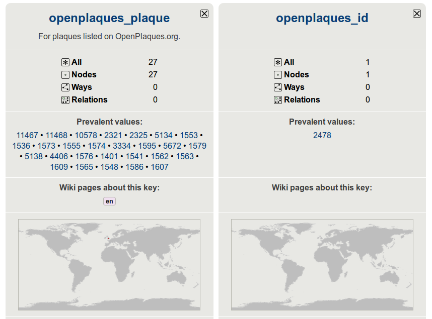
It is now possible to compare tags side by side on a single page. A new menu on tag (and key) pages allows you to add those tags to a comparison list and then compare them side by side. This new addition is great when when trying to decide which of several similar tags is best to use based on popularity/existing use.

Comparing two tags side by side in TagInfo.

Well done Andy for proposing this new feature, and a big thank you to Jochen Topf for implementing it so quickly.

Other new features

The tag comparison is not the only new update to TagInfo. Today the following updates were also added:

  • Maps for Tags
  • Link to Level0 Editor
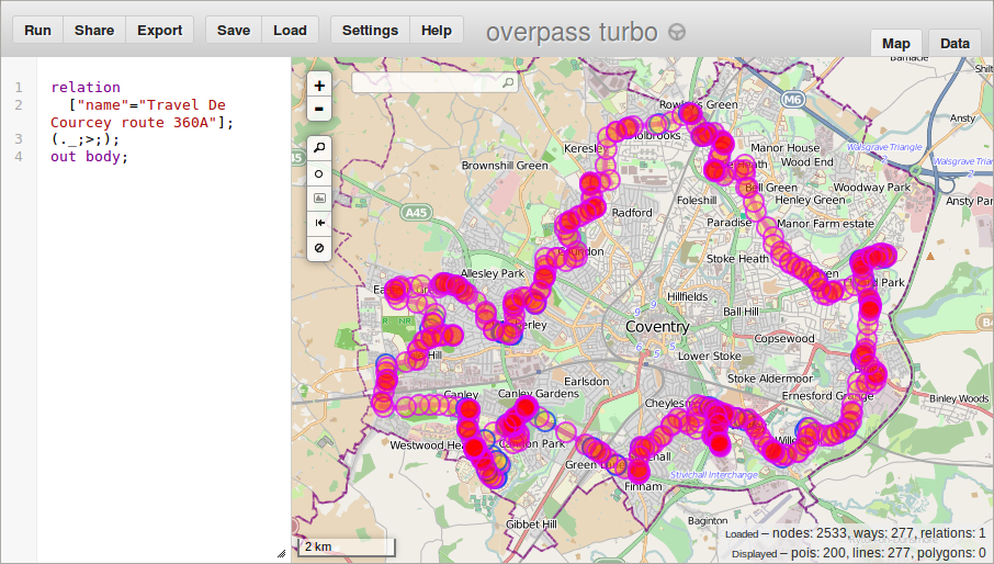
  • Improved Overpass Turbo Integration

In addition to the above improvements, there are also changes to the API and new translations (you can help with translating TagInfo here).

TagInfo is a great tool to help OpenStreetMappers, so I’d personally like to thank Jochen for his work on this. TagInfo is now a core feature of OpenStreetMap (now being hosted on OpenStreetMap Foundation servers). This is a great accolade for TagInfo as it signifies that the website is at the heart of the OpenStreetMap landscape and will continue to be supported going forward.

Mappa Mercia’s May meetings

posted in: Mapping Party, Participate | 0

We are holding two meet-ups this month and to celebrate I’ve rehashed the alliteration in the title of this blog post from our from our March meetings post. I promise the meetings will be more exciting than my writing!

Our two meetings are on the first and last day of the month:

  • Thursday, 1st May: The Edward Rutland, Stourbridge at 7:00pm for our regular pub meet; and
  • Saturday, 31st May 2014: Mapping day in Tysoe (at request of Parish Council – details to follow).

As always newcomers are very welcome to join us and find out more about OpenStreetMap and Mappa Mercia. Try to let us know beforehand so that we can look out for you. Details on the contact page.

You can also view our full Summer 2014 schedule on our wiki page.

Warwickshire Aerial Imagery

posted in: Participate | 1

Warwickshire County Council have kindly provided access to aerial imagery captured during 2013. The imagery is available under the Open Government Licence and can therefore be used for mapping in OpenStreetMap. It comes at just the right time as many of you would have spotted a drop in the Bing aerial imagery (particularly when zoomed right in). It covers both Warwickshire and Coventry and can be used in JOSM, Potlatch 2 and iD using the following guides.

JOSM:

It can be added to JOSM using the following steps:

  1. Click on the “Imagery” menu, then on “Imagery Preferences”
  2. Click on +WMS
  3. Skip boxes 1-3. Instead jump straight to 4 and paste in the following:
    http://maps.warwickshire.gov.uk:80/gs/wms?SERVICE=WMS&FORMAT=image/png&VERSION=1.1.1&SERVICE=WMS&REQUEST=GetMap&LAYERS=Aerial_Photography:Aerial_Photography_2013&STYLES=&SRS={proj}&WIDTH={width}&HEIGHT={height}&BBOX={bbox}
  4. Add a suitable name in box 5 (e.g. Warwickshire aerial 2013).
  5. Click OK.

The new layer can then be added as a background from the Imagery menu (as usual).

Potlatch:

To use this imagery in Potlatch 2 simply click on the “Background” drop down menu. Click “Edit” then “Add”. The the “Name” column enter something suitable (e.g. WarwickshireCC) and in the “URL” column, paste the following:

  • http://draco.openstreetmap.org/warwickshire-aerial-2013/$z/$x/$y.jpg

You can now click the “X” to close the background window. You should now be able to pick the new background layer from the drop down menu.

iD:

Click the “Background Setting” button (stack of sheets) on the right hand side. Next click “Custom” and paste the following URL in the text box:

  • http://draco.openstreetmap.org/warwickshire-aerial-2013/{z}/{x}/{y}.jpg

The new layer should appear automatically.


Coventry Bridge Munch

posted in: Map Improvements, Participate | 0

Sometimes in order to build something better you have to start by taking something old down. That’s exactly what happened in Coventry this weekend. And as always OpenStreetMap was the first to reflect these changes.

Coventry Friargate

The Friargate project is a major redevelopment project in Coventry, right next to the train station. The development encompasses 37 acres and will comprise a vibrant mix of commercial, civic, leisure, residential and hotel space. Currently the site, which will also be home to Coventry City Council’s new council office, is separated from the rest of the city centre by the ring road. Although some good work was done in time for the 2012 Olympics to help connect the Friargate site and train station to the city centre, there was certainly scope for a lot more. That something more, is a new “bridge deck” spanning the ring road:

“The bridge deck is a key part of the Friargate development at the railway station and the council’s own move to a new office building on the site. The bridge deck will better connect Friargate to the city centre by removing the raised roundabout and building a 100 metre wide connection across the ring road, creating a public boulevard linking the railway station through Greyfriars Green directly into Bull Yard.”

As the quote above mentions, stage 1 of the Friargate project was the removal of the existing (road traffic only) raised roundabout. The following image is from Coventry City Councils flickr account:

Junction 6 bridge removal

 Bridge munchers at work on Coventry’s ring road junction 6.

Why I contribute to OpenStreetMap

OpenStreetMap is a free, editable map of the world. It is often described as the wikipedia of maps, but its much more than just a map. All of the underlying map data is made available for anyone to use. You can create your own map style, create mountain bike routes, and many more things that are possible with geographic data. You’re only limited by what your own imagination hasn’t thought of yet!

This weekend, whilst the bridge munchers set about tearing the roundabout bridge down, I set about making the change in OpenStreetMap. Of course I had the easy job – it took only a couple of minutes and didn’t create any rubble or dust!

Using our relaunched mappa-mercia twitter I posted a quick tweet – one that was later retweeted by Coventry City Council:

CovRingRoad_Tweets

The above screenshot is taken from this Storify page created by the city council. It gives a great record of the events in the run up to, and during the bridge removal. I think it nicely sums up the benefit of OpenStreetMap!! Whilst Google Map’s change is still “pending”, the OpenStreetMap change is already live, both on our own maps, and those that use OpenStreetMap data (such as this FourSquare map).

Jump in to editing OpenStreetMap here and you can help too.

Poll: Licence or Addresses

posted in: Participate | 0

Earlier this week Alex (from Mapbox) posted an diary entry on OpenStreetMap with his reasons as to why he feels that OpenStreetMap should drop the “Share Alike” component of its licence. As you would imagine, this created quite a bit of discussion both in the comments of the diary entry, but also on the “talk” mailing list. With the memory of the last licence change still fresh in my mind, I’ve refrained from adding any comment to these discussions, but I did pick up on one of the replies:

Alex states that “The reality is that OpenStreetMap is only used extensively in situations where the share-alike license does not apply, for instance, map rendering.” I’d respond by saying that’s because OSM doesn’t contain a lot of address or navigation data, not because of the license.

The reply above is taken from a longer response by Steve Coast. You can view the full reply here.

Here in the West Midlands we’ve done a lot of work to map addresses and other navigation data (see for example our gritting map), so today we’re simply asking Licence or Addresses? Submit your answer in the poll below.

(Poll is now closed)

Note: This is intended as a bit of fun. The results of the poll represent only an incredibly small part of the OpenStreetMap community and will therefore have no statistical significance. If you don’t like our poll, then don’t submit an answer.

SotM 2013 pledges

posted in: Map Improvements, Participate | 0

One of the things we introduced at State of the Map 2013 in Birmingham was a “Pledge Wall”. The basic idea being that our delegates make a pledge to OpenStreetMap to be completed before the next State of the Map (now known to be in Buenos Aires in November 2014). It’s been six months since State of the Map 2013, so lets see how Mappa Mercia has delivered on its own pledges and those of other people.

  • Pledge: “To complete addresses for one UK postcode region” – A pledge made by our own Brian, and one that he completed in late November for the B11 postcode region. Well done Brian! I’ve also been adding a lot of postcodes to buildings already mapped in the CV3 area.
  • Pledge: “To organise at least one mapping party” – We held a belated Christmas meet-up in Warwick in January and managed to squeeze in some mapping before the light faded. Our next mapping party will be in Worcester on Saturday 15th March. Why not join us.
  • Pledge: “Train and encourage 1 person to be an active mapper” – This one’s always harder to do in Winter as the days are short and the weather (more) unpredictable. We’re looking to work with a local community near Stratford-on-Avon soon and will be providing OpenStreetMap training.
  • Pledge: “To evangelize about OpenStreetMap in central and local government” – For me I see this this as a slow burner. Public sector is generally considered to move slowly and when you add to this the recent cut backs, its not surprising that local government is focusing on delivering their day to day work (and rightly so). It’s not all bad news though. We now have access to Warwickshire County Council’s aerial imagery (a great source for mapping in OpenStreetMap) and Coventry Council are staring to use OpenStreetMap for more of their online maps.

So some good progress after just 6 months. Here’s to some more summer mapping fun!

Mappa Mercia’s March meetings

posted in: Mapping Party, Participate | 0

[Update 2014-03-13: The plans for Saturday’s mapping event in Worcester are confirmed as an afternoon mapping followed by a meet-up at about 5pm in The Crown pub in the city centre.]

Firstly an apology. Inspired by Andy’s recent mailing list email I simply couldn’t resist in adding to the alliteration in the title of this blog post! Sorry folks.

There are two mappa-mercia meetings organised for March. Our regular first Thursday of the month evening meet-up and a Saturday mapping party in Worcester. As always newcomers are very welcome to join us and find out more about OpenStreetMap and Mappa Mercia. Try to let us know beforehand so that we can look out for you. Details on the contact page.

  • Thursday, 6th March 2014: The Bull, Birmingham at 7:30pm for our regular pub meet; and
  • Saturday, 15th March 2014: Mapping day in Worcester (details to follow).

 See you there!

On the Buses

posted in: Map Improvements | 0

Living in Coventry, it’s not often that I get to shout about some new mapping in my city. For most non-Coventrians, the simple fact is that Coventry is dwarfed by UK’s second city, Birmingham, situated just a stones throw away. In OpenStreetMap the situation is the same. There is however one area in which we winning – namely buses!

Route 360 Coventry
Route 360 as shown on Overpass Turbo

Earlier this month a new bus service was announced for Coventry, route 360. At 31.5 miles long it is now the longest route of any city in Europe. Better still the city that has now lost this accolade is… you guessed it, Birmingham!

So how long did it take to add such a long route to OSM? Well, thanks to the great work of Curran1980 this new route was fully mapped within the same week that it was announced in the local media, and a full 2 days before the route actually went into service.

You can view the route relation here and export the data using Overpass Turbo. For more details on Overpass Turbo, see my earlier blog post: Exploring OpenStreetMap data.

Half Way at New Street station Birmingham

posted in: Map Improvements | 0

On 28th April New Street Station got a brand new set of entrances leading to a brand new concourse.

This marks half way in the total transformation of the station.

The old entrances at the eastern end by T K Maxx are now closed and new entrances opened at the western end. If you’re approaching by car the new Drop and Go access is from the west,  off Navigation Street. There’s also a new short stay car park above the station approached from the Drop and Go access road. Anyone arriving at New Street station now has a totally transformed experience of modernity and light rather than the dingy dim experience of before. Congratulations to Network Rail!

Needless to say we had it surveyed and live to the world by lunchtime on April 28th, some 5 hours after the new configuration opened!

Mysterious objects: No 5 in an occasional series

posted in: Observations | 1

I was out walking in the Warwickshire countryside last weekend and came across these unusual objects. Each one was numbered and no more than a couple of meters from the next numbered object. I saw two sets of at least 100 of these, and now release they are located in hedgerows or tree-lined field boundaries that HS2 will cut through (if built).

A small black box (2 by 2 inches and about a foot long). One end is closed and the other end has a small woodern lip.Any ideas?