UK Summer Quarterly Project

Today saw us pass the 1,000 total for farmyards added during this project(1008 to be precise).

Well done to everyone who has participated. What has been the most unusual farm name anyone has come across?

stone_built_slurry_tank_at_moel_y_mab-_part_of_the_leighton_model_farm

Picture Wikimedia Commons: Rod Trevaskus       cc0

Only a couple of weeks left – time to start thinking about our next quarterly project, while we see how many more farmyards we can add.

Birmingham roundabout amongst the most dangerous in the country

posted in: Use The Map | 0

Yesterday the Birmingham Post (our weekly city newspaper) carried a story about the number of accidents on major Birmingham roundabouts. The recently reconfigured roundabout at Bordesley Circus, with an accident every 20 days over the previous six years is the second most dangerous roundabout in the country. That’s a total of 105 accidents.

The Post chose to illustrate its story with graphics based on OpenStreetMap data; showing the site of accidents. Without attribution it has to be said: we’ve already contacted the editor pointing out our attribution policy

The story went on to list the next five most dangerous roundabouts in the city, each with its OSM-based diagram of accidents.

Its always good to see our data being used. Even better to see it being attributed!

We Are Ten

posted in: Mapping Party | 0

August sees mappamercia celebrate its tenth birthday – can you believe it? We didn’t celebrate with a birthday cake but we did meet in Pershore Worcesteshire on Saturday 6th August at the Pickled Plum pub for lunch between morning and afternoon mapping sessions. It was a glorious English summer’s day and we got lots mapped.

Why did we pick Pershore? Mainly because its postcode of WR10 nicely coincided with our birthday. Maybe we’ll be boxing around Worcester postcodes in August every year as we get older- see you next year in WR11!

We had a good turnout of six people and took the opportunity of getting members’ signatures on the Memorandum of Assocation for OpenStreetMap UK Community Interest Company (this is one of the legal documents required to form a limited company).

Here’s Rob Nickerson being the first to add his signature (It was Rob who initiated the discussions many months ago to create a UK chapter of OSM)

Signing

Busy days

posted in: Participate, Use The Map | 1

Yesterday I attended the Landor Future Highways Conference at the new iCentrum building on Birmingham Science Park, at the invitation of the Birmingham ODI (Open Data Institute) node. It was good to see so many OSM maps being used by presenters (thankyou Devon County Council and TransportAPI). I  was provided an adhoc slot into the programme to deliver a lightning 5 minute presentation about OpenStreetMap (thankyou Birmingham ODI node). It was a bit daunting presenting to highway professionals, especially in front of a screen the size of an IMAX cinema!

Then it was off to Leicester to train new volunteers in editing with iD, as part of Leicester City Council’s walking-mapping project which is an  extension of their weekly Leicester health Walks. Thanks to Sara for organising the training and to Chris, Alan, Stan and AJ who took their first steps editing OpenStreetMap. We all look forward to you increasing the data coverage in Leicester.

I’ve just about finished the edits from our June mini-mapping party in Kidderminster  from 2 weeks ago, when guess what?  Our July mini-mapping party is tonight in Tamworth – everyone welcome. We’ll be meeting in the Globe Inn Lower Gungate, Tamworth B79 7AT at 8pm.


A surprising rural waymarked walk in the heart of a city

Dudley, in the heart of the Black Country in the West Midands, is not the sort of place you’d envisage a rural walk. The Black Country is so-named for its iron and coal and industrial might. Some  have claimed the furnaces and mines of the Black Country were the basis for JRR Tolkien’s Mordor in Lord of the Rings. Most of the industry has now disappeared and left lots of brownfield sites, crumbling industrial buildings and a struggling economy, with its associated social problems.

I have recently walked, surveyed and mapped the Limestone Walk. And  what a delight it was!  It was easy to forget the adjacent presence of a dense urban environment. The walk is poorly publicised and poorly mapped (the waymarking can be poor in places also). I could find little on the web which could act as a practical guide for anyone wanting to walk this route. The best I found was from the excellent Discovering Britain resource provided by the Royal Geographical Society.

So I thought – here’s an opportunity to demonstrate the capabilities of OpenStreetMap. This is the result of my efforts, taken from Lonvia’s Waymarked Trails

Limestone Walk

The walk commences at the ruins of Dudley’s mediaeval Priory and ascends Castle Hill (unfortunately Dudley Castle and its zoo are a paying attraction so the walk has to avoid them). Castle Hill is riddled with collapsed limestone mines and also with canal tunnels. A small diversion to the Black Country Living Museum is well worth the effort: it provides an extensive depiction of the industrial and social history of the Black Country.

But the jewel in the crown of the walk has to be its passage through the Wren’s Nest National Nature Reserve. It has been a national nature reserve since 1956 and there is currently a bid to place it in  wider regional GeoPark. It is world famous geologically for its well-preserved Silurian coral reef fossils and is one of the most diverse and abundant fossil site in the British Isles.  It is also famous historically for here it was  that the Scottish palaeontologist Sir Roderick Murchison studied the fossils and rock formations that led to him defining the Silurian System. 

The crater Murchison on the Moon and at least fifteen geographical locations on Earth are named after him. These include: Mount Murchison in the Mountaineer Range, Antarctica; Mount Murchison, just west of Squamish, British Columbia, Canada; tiny Murchison Island in the Queen Charlotte Islands in the same province; Murchison Falls (Uganda); and the Murchison River in Western Australia. The town of Murchison in the Tasman Region of New Zealand’s South Island was also named after him. It would be interesting to discover how many of these are mapped in OpenStreetMap.

The walk culminates on Sedgley Hill.  At 277m, reputedly the next highest point East is in the Ural Mountains. There are stunning views over much of the West Midlands, Staffordshire and Worcestershire; Birmingham’s city centre with its cluster of tall buildings can be seen in the distance squatting as it does on a low ridge.

Dudly Council, under severe financial pressure, is doing it best to improve the infrastructure of the walk and to promote its use.I hope OpenStreetMap’s resource can be of use to them.


Colonisation by street cabinet

posted in: Observations | 0

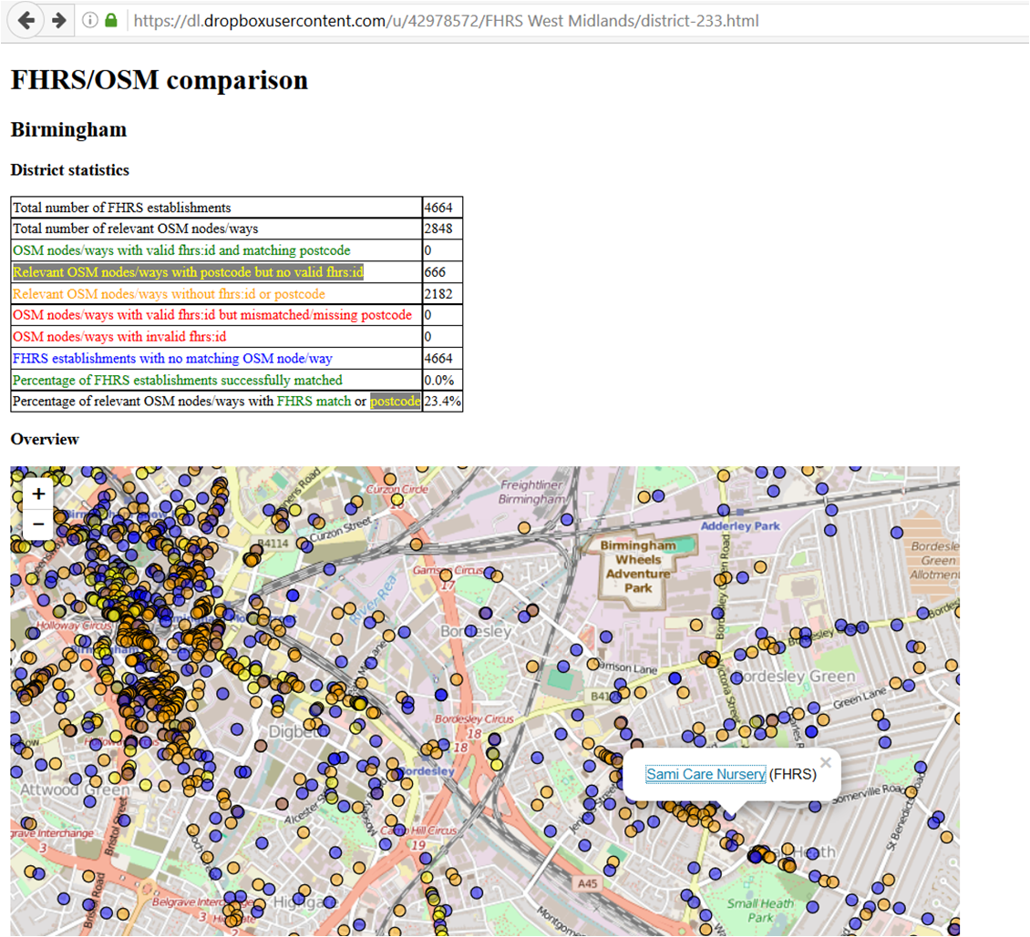
Man_made=street_cabinet is not the most popular tag or object to map: there are only 753 instances in the UK according to taginfo.

However ……they are proliferating at what seems a high rate judging by my recent surveys. I started noticing street cabinets as part of a traffic management project which Birmingham City Council invited OSM to design a tagging scheme for  traffic sensors associated with controlling traffic signals and assist in editing and quality control (more on this later, but probably after SotM 2016, where it will feature in a talk I’ll be giving)

Even if you don’t have a local project like this, traffic signal cabinets usually have  a reference number on them to identify a set of signals and are useful for identifying them. For our project the reference number matched the sensor node  reference number on the traffic management network – so it was a useful way of OSM  mappers on the ground cross-checking centra data held by the Council. Who knows, if you map enough of them in your area, someone will find a use for the data?

By the way  individual traffic signal poles can also have reference numbers, but I’m not advocating they all get mapped!

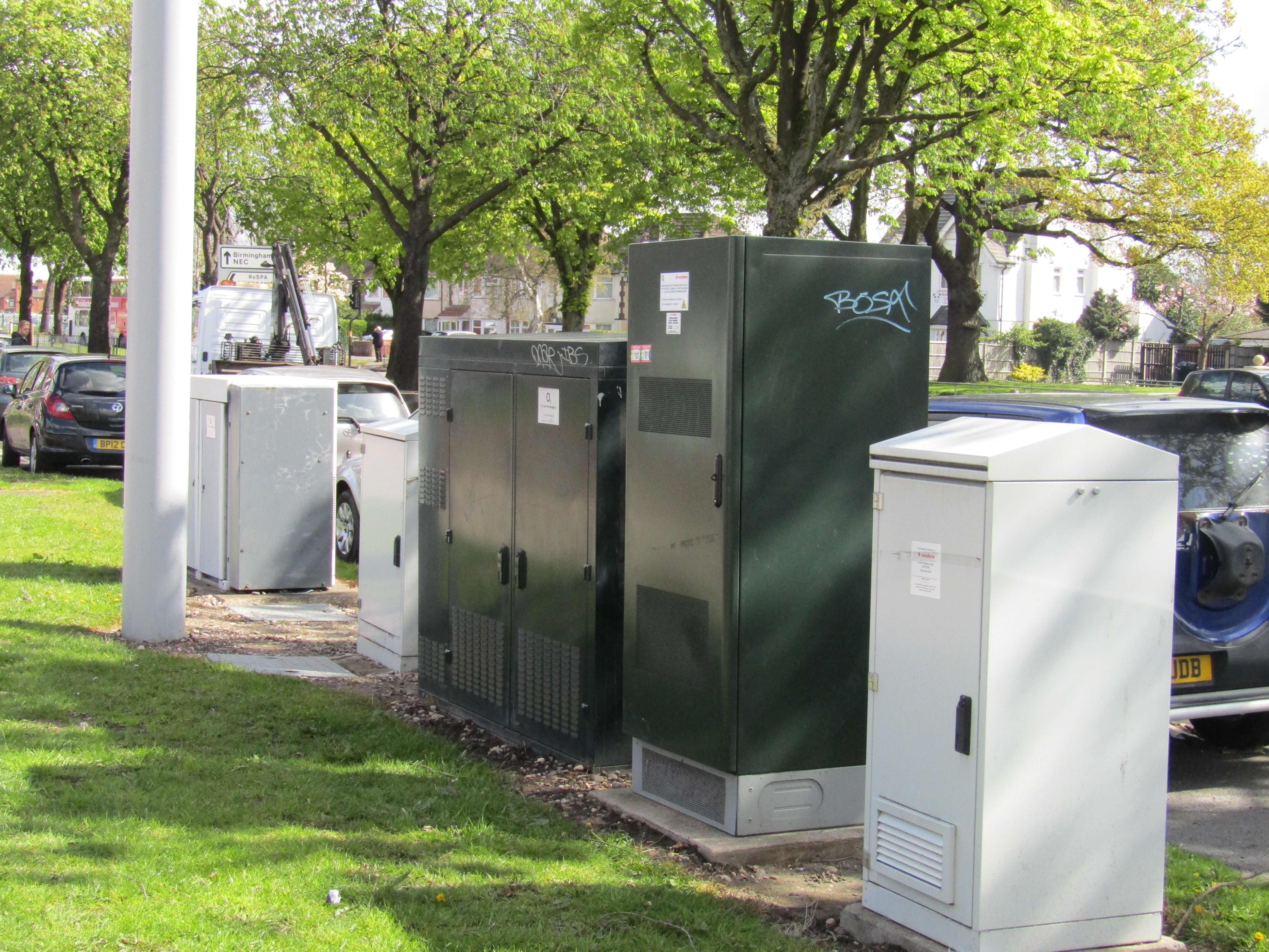
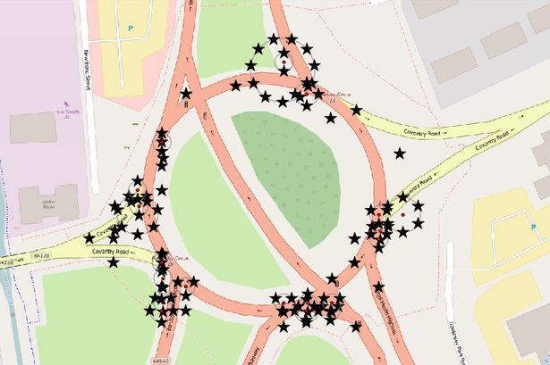
But back to proliferating street cabinets- always communications cabinets adjacent to phone masts. Not only are they proliferating – they’re growing in size. Some are now the size of refigerators. The  collection shown here was definitely not there when I first surveyed this phone mast several years ago. The smallest one second from the left was all that was there. I guess the proliferation is down to the phenomenal growth in mobile data traffic, and possibly the sharing of masts by mobile network providers. I have seen one surrounded by 7 such cabinets! Can anyone beat that?

street cabinets

Should we bother mapping these? It’s down to individual preference I guess, OSM is not going to be deficient without them.

Perhaps when they become covered in graffiti and are transformed into tourism=artwork? The local taggers have already made a start on these.

But they are a significant physical presence and we do map other objects which are much smaller (most of which, it has to be said, are immediately useful, like benches, mailboxes, litter bins etc). I shall periodically amuse myself by adding significant clusters of these to OSM data.

The things you notice once you start surveying and editing with OSM!

Visualising Food Hygiene Rating Scheme (FHRS) and OSM data

Greg Swinford has  developed some tools for visualising Food Hygiene Rating Scheme (FHRS) and OSM data, finding possible matches between it and importing useful tags into JOSM.

FHRS data is a useful source of postcodes and addresses, and it can also be a helpful reminder of local establishments to add to the map. The tools will  help us to efficiently add and verify data in our local areas (rather than importing large amounts of data automatically).

FHRS is a central government scheme run by the The Food Standards Agency: the inspections are carried out by local authorities.The food hygiene rating or inspection result given to a business reflects the standards of food hygiene found on the date of inspection or visit by the local authority. The food hygiene rating is not a guide to food quality.

Greg has  created a set of maps (one per OS Boundary Line district) for the West Midlands and uploaded them here: https://dl.dropboxusercontent.com/u/42978572/FHRS%20West%20Midlands/index.html <https://dl.dropboxusercontent.com/u/42978572/FHRS%20West%20Midlands/index.html>.

Greg doesn’t have the time or computing resources to update the data very regularly or to widen the geographical area beyond the West Midlands, but the code is freely available at http://github.com/gregrs-uk/python-fhrs-osm <http://github.com/gregrs-uk/python-fhrs-osm> if anyone would like to use it.

The tools are a fantastic resource, enabling you to find estbalishments that haven’t been mapped and also for adding addresses and postcodes for thos that have already been mapped

FHRS 1 When you click on a POI you get the FHRS data:

FHRS 2

Summer Programme

posted in: Mapping Party, Participate | 1

To take advantage of the good weather and light evenings during the summer months we tour around the region mapping areas which look either interesting or not well-mapped.

So far this year we have visited Stratford-upon-Avon where we attempted to map all the tourist accommodation (it is the 400th annivarsary of Shakespeare’s death and this town is a global tourist destination). The ongoing project is to map all the buildings – help appreciated!

Last week saw us in Atherstone where our mapping effort was eclectic to say the least

We have mapped out the remainder of the venues:

June will be Kidderminster on a Saturday ( pub & date tbc)

July will be Tamworth Wed July 6th (Globe Inn, Lower Gungate)

August is the 10th anniversary of mappamercia so we’re going to map as much of WR10 as possible, centred on Pershore (pub & date tbc)

September will be somewhere in Herefordshire (some input from mappers in Herefordshire appreciated – given the distance involved for most attendees this will probably be a Saturday too)

Unusual Objects – an occasional series

posted in: Uncategorized | 3

Whilst surveying to collect data your day might be enlivened by spotting something out of the ordinary which might be of some interest or amusement to fellow mappers.  (Sharing with family or friends usually just confirms their view of your strangeness!)

So here’s one I spotted in North Birmingham

Dovedale Road Perry CommonWhy is this unusual? British pillar boxes (post boxes for depositing mail for non-UK readers) are usually painted bright red which has given rise to the generic marketing name of “Pillar Box Red” for pigments in a wide range of consumer goods.

Why this one is painted pink and who painted it are mysteries.

I know of only two other colour variants for Royal Mail pillar boxes:

The first is gold for some pillar boxes to celebrate the London 2012 Olympics ( are they all mapped in OSM I wonder?)

The second are the ones painted green in Ireland after independence (are they still there, or have they been replaced in a wave of modernisation?)


“Real Time Mapping” – an update

posted in: Uncategorized | 1

Birmingham City Council is now well into its project to convert many of its streets to a 20 mph speed limit (see previous blog here). We’re receiving regular weekly updates as to what work will be completed in the current week and what work is planned for the upcoming week. These are in fact the internal reports used by the City Council Cabinet to review progress. So, every Friday the map gets updated with new 20 mph maxspeed tags. This map shows which roads have been updated by the contractors. So far we have added 3 weeks’ worth of work

Not quite “real-time” but a significant first step in showing how organisations can use OpenStreetMap to create dynamic up-to-date maps. Thanks are due to Birmingham City Council’s staff in trying something new and co-operating with us.