Massive Release of Highways Asset Data in Birmingham

posted in: Uncategorized | 1

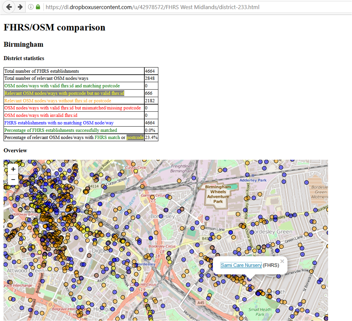
This month Amey released a number of  open datasets to Birmingham City Council, which has published them on its Data Factory site under an OGL licence

Amey maintains Birmingham’s highways under a 25 year Highways Maintenance and Management Service, which is Europe’s largest local government highways partnership.

It covers 2,500km of roads, 4,200km of footways, 95,000 street lights, 76,000 street trees, around 1,100 traffic light signals and over 1,000 bridges, tunnels and highways structures. Winter services involve gritting 1,200km of road every night during freezing weather, maintaining 1,265 grit bins and treating priority pavements in icy conditions.

The datasets cover: trees, traffic signals, streetlights and gullies (points where surface water drains off the highways) as at December 2016

The tree dataset seemed the most interesting to us, especially with relation to other datasets for air pollution that are being generated. A review of the data showed its positional accuracy to be pretty good: none of us have specialist knowledge about tree species so we are accepting the accuracy of Amey’s data.  Amey’s data contains details of the species, estimated age and shape of the trees as well as other identifiers.

Currently we’re engaged in importing the tree dataset which we’re doing on an area basis so that we can do a human review and delete existing trees which have been added from various aerial imagery sets. One of the benefits of  this method is to eliminate trees in the Amey dataset that are identified as “assets to be de-accrued” – these refer to trees that have been removed either because of highway improvements, storm damage, disease or safety.

It’s a great shame to pass a highway junction where you’ve just imported the trees to see the tree surgeons at work felling them all in preparation for a junction improvement!

We have of course raised with the Amey the question of how the dataset is to be maintained as open data. It would be such a shame for our hard work and their welcome initiative to degrade over time because there is no mechanism for updates of additions and deletions.

We’re not sure yet what to do with the other data. The traffic signal data is probably the next most interesting. We’ve taken a brief look at this and our current thinking is to import the data as untagged nodes and gradually manually transfer the UIDs to adjacent traffic signals, deleting the imported node. We’re pretty confident that with previous work we’ve done in collaboration with Birmingham City Council we’ve captured most of the traffic signals; and any way trees are going to keep us occupied for a few weeks.

We’ll keep you posted.

Visualising Food Hygiene Rating Scheme (FHRS) and OSM data

Greg Swinford has  developed some tools for visualising Food Hygiene Rating Scheme (FHRS) and OSM data, finding possible matches between it and importing useful tags into JOSM.

FHRS data is a useful source of postcodes and addresses, and it can also be a helpful reminder of local establishments to add to the map. The tools will  help us to efficiently add and verify data in our local areas (rather than importing large amounts of data automatically).

FHRS is a central government scheme run by the The Food Standards Agency: the inspections are carried out by local authorities.The food hygiene rating or inspection result given to a business reflects the standards of food hygiene found on the date of inspection or visit by the local authority. The food hygiene rating is not a guide to food quality.

Greg has  created a set of maps (one per OS Boundary Line district) for the West Midlands and uploaded them here: https://dl.dropboxusercontent.com/u/42978572/FHRS%20West%20Midlands/index.html <https://dl.dropboxusercontent.com/u/42978572/FHRS%20West%20Midlands/index.html>.

Greg doesn’t have the time or computing resources to update the data very regularly or to widen the geographical area beyond the West Midlands, but the code is freely available at http://github.com/gregrs-uk/python-fhrs-osm <http://github.com/gregrs-uk/python-fhrs-osm> if anyone would like to use it.

The tools are a fantastic resource, enabling you to find estbalishments that haven’t been mapped and also for adding addresses and postcodes for thos that have already been mapped

FHRS 1 When you click on a POI you get the FHRS data:

FHRS 2

End of our JOSM paint styles

posted in: Uncategorized | 0

Several years ago we created JOSM paint styles to help with the task of mapping gritting routes. The styles made it easier to identify which roads had the gritting tag.

The recent versions of JOSM have changed the requirements of these style plugins therefore breaking our code. If you still use the style you will see the following message that gives the reasoning and how to fix the problem. The style plugin would need to be updated to the latest MapCCS code.

Warning

This applies to both our josm-style.xml and josm-preset.xml code. Currently we have no plans to update these style plugins to the latest MapCCS code, however we welcome support from others to complete this update. If someone can come forward we will upload the new code so the functionality continues to work. For now, to prevent the warning message popping up each time you start JOSM, simply go to “View -> Map paint styles -> Map paint preferences” and delete “Winter Gritting” and “Winter Gritting2”.

We apologise for any inconvenience this causes.

Unusual Objects – an occasional series

posted in: Uncategorized | 3

Whilst surveying to collect data your day might be enlivened by spotting something out of the ordinary which might be of some interest or amusement to fellow mappers.  (Sharing with family or friends usually just confirms their view of your strangeness!)

So here’s one I spotted in North Birmingham

Dovedale Road Perry CommonWhy is this unusual? British pillar boxes (post boxes for depositing mail for non-UK readers) are usually painted bright red which has given rise to the generic marketing name of “Pillar Box Red” for pigments in a wide range of consumer goods.

Why this one is painted pink and who painted it are mysteries.

I know of only two other colour variants for Royal Mail pillar boxes:

The first is gold for some pillar boxes to celebrate the London 2012 Olympics ( are they all mapped in OSM I wonder?)

The second are the ones painted green in Ireland after independence (are they still there, or have they been replaced in a wave of modernisation?)


“Night School” status report

posted in: Uncategorized | 0

Yesterday the mapping community in the UK held an online “Night School” mapathon to hep map schools. So how did we get on?

We did it! Yesterday we set the record for the highest number of edits to amenity=school features in the UK. Between us we edited 405 schools beating our previous high from 18th January.

Looking at the detail we created 202 new school polygons (a 33% increase on our previous daily best) and modified 191 ways. The other edits (12) were to nodes.

We are now at 75.5% of all UK schools mapped as ways (according to Robert W’s fantastic progress tool). This is up from just 62.8% when we started this task at the start of January. All but 10 postcode areas are above 50% complete. When we started there was 30 below 50% (8 below 40%). At the top end we have 24 postcode areas 95+ percent complete. Compared to zero when we started!

A total of 38 people edited during the day – again, another record! And the edits of those who used the #OSMschools comment in their changesets can been seen here.

Thanks for the amazing effort today. I hope the MapRoulette task is proving popular and will encourage more edits in the least loved parts of the UK OSM map.

Who’s involved? Edits to OpenStreetMap

posted in: Uncategorized | 2

We have many ways to follow the progress of the fifth quarterly project – schools. One such method is to look at the changesets that include the comment “‘#OSMSchools”. We can visualise these as a map, or in this case by a simple total of the changesets completed per user.

As the list has now grown to over 40 people, I am posting it here rather than on the wiki. There are of course other ways to see who is involved, including the school edit tracker provided by Harry. This counts edits to features tagged “amenity=school” therefore getting round the problem of needing to include #OSMSchools in the changeset comment. Where a changeset can include any number of school edits, Harry’s tool counts each on individually.

Please continue to use #OSMSchools in your changeset comments. I will update the wiki to link to this post and to retain user comments (e.g. where you are mapping, how you are helping).

Username Changesets
brianboru 277
ecatmur 276
EdLoach 191
lsces 165
Hobgoblin 164
southglos 159
RAC_UK 111
bogzab 110
Yorvik Prestigitator 84
sdoerr 81
Gregory Williams 77
Mark_S 57
LollyMay 53
SpillerC 50
Fledge 48
ACM 45
trigpoint 44
blackadder 40
Portree Kid 36
lakedistrict 30
DaveF 29
GinaroZ 29
sjreynolds143 29
robbieonsea 19
Jez Nicholson 13
RobJN 13
SK53 12
will_p 8
LivingWithDragons 6
The Maarssen Mapper 6
Tom Chance 6
RAytoun 4
seumas 4
BCNorwich 2
Chris Fleming 2
JonS 2
jpsa 2
mcld 2
fitzsimons 1
ndm 1
Richard 1
Total Result 2289

“Real Time Mapping” – an update

posted in: Uncategorized | 1

Birmingham City Council is now well into its project to convert many of its streets to a 20 mph speed limit (see previous blog here). We’re receiving regular weekly updates as to what work will be completed in the current week and what work is planned for the upcoming week. These are in fact the internal reports used by the City Council Cabinet to review progress. So, every Friday the map gets updated with new 20 mph maxspeed tags. This map shows which roads have been updated by the contractors. So far we have added 3 weeks’ worth of work

Not quite “real-time” but a significant first step in showing how organisations can use OpenStreetMap to create dynamic up-to-date maps. Thanks are due to Birmingham City Council’s staff in trying something new and co-operating with us.

Kirkcaldy postcode leads the way

posted in: Uncategorized | 0

It has been amazing to see the level of activity for the fifth OpenStreetMap UK quarterly project – schools. So far nearly 300 schools have been mapped or improved by 22 people. The Kirkcaldy postal area – KY – leads the way with over 30 schools mapped.

At just 10 days in, the community of mappers have:

  • created a number of amazing tools to help identify missing or incorrectly mapped schools;
  • agreed on new tags to allow us to reference the English Edubase and Scottish Executive Education Department data; and
  • made massive progress on mapping.

So which area is leading the rest? Based on Robert W’s comparison tool, here are the top 10 most improved postal areas. This is measured by the increase in OpenStreetMap objects that “match” the government data between 2016-01-05 and 2016-01-10. Other measures are of course possible and may show a different picture.

KY leads the way in our list of top 10 most improved regions.

Well done to the Kirkcaldy postcode area, KY, for heading up our leadership board. Great work!

There is still plenty of time to get involved with adding schools to OpenStreetMap, the worlds largest crowd-sourced and most up to date map. A list of useful resources can be found here. Not sure how to map? No worries. Check out our tutorials, get in contact with us, or if you are in the West Midlands why not pop along to our next social and find out how.


Improve OSM – Traffic flow direction

posted in: Uncategorized | 0

At the end of October Telenav released a tool to help identify incorrectly tagged, or missing, one way streets in OpenStreetMap. The tool makes use of the data they collect through their Scout Navigation app and compares this against OpenStreetMap data. If the scout data shows that drivers only travel in one direction down a street it the tool checks for a corresponding oneway=yes tag in OpenStreetMap. If it doesn’t find it then it flags up a potential error.

The potential errors can be viewed at the Improve OSM website, but the best way to use it is with the “trafficFlowDirection” plugin for the JOSM map editor:

  • Download the “trafficFlowDirection” plugin for JOSM.
  • After restarting JOSM add the Bing background via the Imagery menu. The Traffic Flow Direction layer should add itself to the list of visible layers automatically.
  • Zoom to a potential oneway error as identified by the orange circles (when zoomed out) and the orange arrows (when zoomed in).
  • Download and fix the OpenStreetMap data if appropriate.
  • So others know the error has been fixed (or marked as invalid if appropriate) mark the issue as Closed (or Invalid). Do this by first making the TrafficFlowDirection layer active and selecting the issue you just solved:activate

    Then click the green lock in the plugin panel, add a comment, and close the issue.

  • Don’t forget to upload the improved OpenStreetMap data when you have finished.

Full instructions can be found here.

The Current Situation

posted in: Uncategorized | 0

The Current Situation is a collection of work by artist Yara el-Sherbini, whose centrepiece is an interactive sculpture of a map of the world. It is large, 7.8m wide and 3.5m high with steps leading up to the rear. I saw it at its current location in Wolverhampton Art Gallery. I popped in whilst I was surveying some listed buildings (heritage buildings for readers not in the UK).

The work is an impressive sculpture but its true nature is not revealed until the audience engages with it. As you can see from the picture it emulates a children’s game where you have to trace around the object with a metal implement without touching it. Here you trace around the national borders and should you touch one, red lights flash onto the sculpture, buzzers sound and the metal implement in your hand vibrates strongly. Just as in real life, navigating borders becomes a matter of tactics and skill and should you transgress the rules, alarms and shocks await you.

IMG_1056

Again as in real life, some people participate and some watch from the sidelines. It’s only when you play that the real dynamic of conflicts, dangers and exploration becomes apparent. What if no-one plays? Then the sculpture just becomes a beautiful metal map of the world, a static monument which might be seen in many public places around the planet, representing a harmonious, static view of a united world, one that is controlled and restricted.

I found it a clever and thoughtful piece which questions the unspoken cultural components and geopolitical struggles present in a map. You can study a map and only see a small representation of its true content. As the exhibition guide says: ” El-Sherbini’s shock tactic speaks to the physical and legislative strategies used by governments to reinforce and control their borders: from walls, barbed wire, electrical fences, manned and unmanned surveillance, to visa restrictions and immigration curbs.”

The collection is on tour nationally so watch out for it