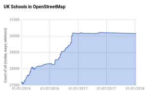
When we did the highly successful quarterly project to map schools we tracked the progress using a script that collated data on a daily basis from TagInfo UK. This enables us to see how we are getting on, both in terms of total features mapped, but also the split between nodes, ways and relations. We can then produce charts like the one for schools shown below.
This script was also used on the following quarterly projects up to the end of Q1 2017. Unfortunately I failed to set it up for the following quarterly projects, and worse still, failed to notice that the script stopped running in May 2017. It looks like the reason behind this was a change in the server that we are hosted on causing a 32bit vs 64bit error – but I’m no expert!
The important thing is that I have it up and running again and have added tracking for petrol stations. You can view the data by following this link.
Christian Ledermann
schools.mapthe.uk went online august 2017 https://schools.mapthe.uk/import-log/?page=63 and ~ 3000 schools were added with that tool – which shows nicely in the graphic
RobJN
Yes, the initial growth is as a result of our Q1 2016 mapping project but the second bit is due to the schools.mapthe.uk tool. The early growth hides a lot of detail as it is total count and there was a big effort to remap nodes to ways and to remove node + way duplicates. There was some tools to track progress but otherwise this was a manual process. As shown the introduction of schools.mapthe.uk greatly sped up the process.
Have you considered applying it to any other dataset?