Fix that road name! Progress Report

posted in: Uncategorized | 2

Well done to the folk in:

City of Leicester, Bradford, Darlington, Redcar and Cleveland, Hartlepool, Shetland Islands, Sheffield,  Berwick upon Tweed, Rutland and Guildford

You are our leaders in our first quarterly project.

How about Liverpool, Fife, Rotherham, and Manchester, all with over 200 road name errors, getting up amongst the leaders?

A challenge to anyone with coding skills:

Can we take the data on which ITOworld work, from where  the data shown above comes, to make it personal, so we can see who is doing the editing- similar to the daily “leader board” for Irish townlands?

We have corrected 247 road names in the last week. So if we continue at this rate we should have completed another 2,223 by the end of the quarter. Let’s see if we can build on this and make a bigger dent in the task. Otherwise we’ll still have another year and a half to complete it – and that’s without the OS Locator updates adding more corrections

Fix that road name! A brief tutorial on using OS Locator in JOSM

posted in: Uncategorized | 1

Switching on the OS Locator imagery  in JOSM for missing/mismatched UK road names is a great way to see what needs to be done in any area when you’re editing. You can enable this in JOSM from Preferences, selecting the WMS/TMS button and scrolling down the list of imagery providers to the GB section and choosing OS OpenData Locator

You can then toggle between Bing Imagery and the view you’d see below

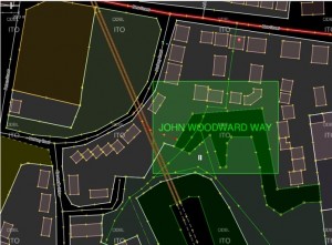
John Woodward Way Before

The green box indicates the extent of the missing road named John Woodward Way. Now that can be a good indicator of the extent of the road and if the Bing imagery is up-to-date then a toggle to that could confirm its layout. However in this case the Bing imagery is so heavily shaded that the road was not visible, even though  the building outlines were.

So a survey was necessary, but because of the adjacent pylon my GPS trace was rubbish so using the building outlines and some photographs I was able to insert the highway=residential tagged way,with name confirmed from the street sign.

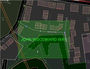
John Woodward Way After

You’ll notice from the end result that I was able to improve the locality’s map by adding some addresses, traffic calming and remove a footpath which no longer exist, which is a great byproduct from fixing road names.  The rectangular box is a good fit to the actual layout: but you do need either good Bing imagery or a survey to confirm.

Fixthatroadname! reveals a surprise discovery

What makes contributing to OSM so enjoyable is the unexpected discoveries it throws at you. Today I went surveying in West Bromwich to resolve two OS Locator road name issues. Neither was in any remarkable and apart from adding a few addresses and POIs not very productive. In mitigation the weather was rather foul and not conducive either to writing notes or taking photos.

But once home and conducting some web research on the area I came across this Daily Mail article concerning the misnaming of a road named in honour of a local WWI hero, winner of the VC (Britain’s highest award for bravery).

The soldier’s name was Robert Edwin Phillips and the council had mistakenly named the road Edwin Phillips Drive . Rather than re-name the road correctly, mainly because residents objected according to the Daily Mail article, the council decided to add a supplementary plate reading ‘Commemorating West Bromwich-born Capt. Robert Edwin Phillips V.C., 1895-1968. Awarded the Victoria Cross during the First World War.’

Only three more names road names to resolve in Sandwell ( the council in whose area West Bromwich is located): I wonder what surprises are in store?

Surprise yourself – go out and survey some OS Locator name mismatches!

FIX THAT ROAD NAME

We’re trying to build the UK OSM community with Quarterly Projects – our first project is FIX THAT ROAD NAME.

If you’re new to all this then the first port of call should be the OS Locator wiki page.

It’s a good idea to have the OS Locator imagery layer ON during editing so you can see where there are errors as you edit. Advice on how to do this is on the OSM and OSL differences tileset page

GOLDEN RULES

1.Concentrate on areas you know well and can reach easily in case a survey of the road name is required

2.If an OSM road has a name that is different from the OS Locator name then it definitely should not be changed UNLESS you have definite local knowledge OR you have surveyed it.

3.If your name for the OSM road is different from OS Locator then once you’ve corrected or entered the name you need add the tag not:name= nnnnnnn where nnnnnn is EXACTLY the OS Locator name.

4.If an OSM road has no name but OS Locator has then you MAY add the OS Locator name AS LONG AS you add the tag source:name=OS_OpenData_Locator. This is because OS Locator often has an incorrect or mis-spelled name and this enables other editors at a later date to scan an area using this tag to further improve the data should this be the case. There is a division of opinion amongst veteran mappers about this: many hold that ONLY surveys are legitimate, but as long as you tag with source:name=OS_OpenData_Locator then this is acceptable as the vast majority of OS Locator names are correct.

There are some special cases which will be dealt with in a separate blog.

If you need help then either subscribe to the talk-gb mailing list. Instructions here

or email or phone your query to us using one of our contacts

And don’t forget – as you correct and add road names you’ll always find other things to improve!


Change: How mature is OpenStreetMap?

posted in: Observations | 21

There have been a couple of threads on OpenStreetMap’s mailing list this month to do with change. The first, entitled “Request for feedback: new building colours in openstreetmap-carto”, is all to do with a change to the way the default map style looks on openstreetmap.org. The second, “MEP – pipelines”, refers to a mechanical edit of the OpenStreetMap data. Both have been met with some level of resistance – but is this proportionate?

Change: For and Against

Failure to adapt and change can result in obsolescence and opens the door for new innovative competitors. The same is true for OpenStreetMap. We rely on an army of mappers to continue to contribute data and many of these mappers are motivated by the idea that the map data is being used and not just sitting idle. As our users’ needs change, so do our contributors’ – we are faced by a constant requirement to adapt. Fulfilling these requests for change in a timely manner is great for the long term success of OpenStreetMap.

Take tags for example: we don’t have a rigid set of tagging rules and as such contributors can come up with their own tags for new, never mapped before features. Over time preferred tags become more populous and gradually more contributors adapt to use the common tag – old tags may even get updated. If our contributors didn’t change then our data would be a miss-match of ‘stuff’ and would be difficult to add to and problematic for our end users.

But change is not always a good thing. Those same users who require us to adapt, are also likely to want us to provide a stable product. Our users have products and services that rely on our data and when we change something they may also need to update something on their side. As such unrequested change, or change with insufficient notice, may cause as much problems as a failure to adapt when desired.

“As OpenStreetMap matures the amount of prior notice of changes we will be expected to give will increase and we will be expected to announce planned changes to some of the smaller things”

Change in OpenStreetMap is often done in small evolutionary steps, however we’ve seen big changes too, such as the licence change and the introduction of new editing software. As OpenStreetMap matures the amount of prior notice of changes we will be expected to give will increase and we will be expected to announce planned changes to some of the smaller things, not just the big ones.

So lets look at the two changes currently being discussed on the mailing list.

Case 1: “Building colours in openstreetmap-carto”

This first change is to do with how the default map style on openstreetmap.org looks. It forms part of a larger piece of work to bring some standardisation to our default style. The changes come after a period of stagnation a few years ago during which it was often commented that our map style was a hotchpotch of colours, line styles and widths. The current changes bring standardisation and set the foundations for us to add new POIs (another often requested change). The general lightening of the style also makes it more suitable as a background layer to display overlaid data (again, often requested).

But who are the affected users? Well, OpenStreetMap is a data project – we create data and we distribute data – its right there on the wiki home page. The default map style, on the other hand, is provided as an additional extra: a bonus. We specifically limit the use of our default map through our ‘Tile Usage Policy’.

If you are an end user and are not happy with the change then you have an alternative. Simply grab our underlying data and render your own map using any style you wish. You could even use a previous openstreetmap.org default style!

Case 2: MEP – pipelines

This second change is a data change. It follows my example above where some work has been done to try to improve the tagging of a certain feature – in this case pipelines. The aim here is to create new use cases for our data. Although it hard to be certain, I would imagine that very few users are currently using our pipeline data. As such a notification of change, followed by a reasonable period of time for people to adapt is probably appropriate.

But was change even needed? Possibly yes – the aim is to improve both the quality and quantity of our data and to avoid potential conflicts with other tags. On the other hand, these conflicts are minor and most data users could work around them. So change may not be needed.

In this case I tend to look at the bigger picture. We have a group of contributors who are trying to help, and we probably don’t have many users of the pipeline data right now. If we block the change we won’t cause problems for our users (until they come to us and tell us that we’re not adapting to their needs!) but we risk putting a group of dedicated contributors off OpenStreetMap for good. In this case I believe the best solution is to support the change.

Your thoughts?

I’d love to hear your thoughts on this – where is OpenStreetMap in its maturity and what level of change is appropriate? Is there anything you would like to see changed? And is there anything that must stay the same?
Suggestion for OSM UK quarterly projects

At a recent pub meeting  mappa-mercia mappers felt that UK  OSM contributors are all busy on their own specific projects and apart from the occasional discussion on the talk-gb mailing list don’t really get together as a community. Compare that to the Irish community where there is a real drive on one large project to complete the mapping of townlands by 2016. There’s a real buzz about this with some fantastic tools and data visualisations, chat, problem solving, and  a great series of instructional videos. You feel a real part of a community if you participate.

So to try and rectify this we’re starting a campaign in the West Midlands, which we hope will be adopted by mappers all over the UK. Each campaign will last for 3 months – plenty of time to achieve something big,  work together as a community on a common goal, whilst leaving you time to work on your own projects alongside.

Task 1: Check that road name!

The first task is to add missing road/street names and to correct misspelled or misnamed roads. Reasoning? This is a basic geographic data requirement  for a map and we have some way to go in the UK to achieve completion.Until we complete this we’ll always lack credibility.

This task has been slowly ticking along but it’s currently both lonely and tedious. There’s a great opportunity to get out to some areas that haven’t been touched for some time;  come up with some new ideas to involve newer mappers, reactivate mappers who have ceased mapping, possibly even coordinating with housing developers to keep OSM right up to date. And more…. we’re looking for ideas and actions to reach out to develop a community here.

The latest release of OS Locator data gives everyone the opportunity to get out there and chase down the latest set of road name revisions. ITOworld’s OS Locator tracker shows us at 98.14% completion. There are 14,639 major issues and 2,125 minor issues (mostly involving the use of apostrophes). (You need to register to use this tool).

If we take the end of the quarterly project as  March 31st 2015 we need to correct 197 road names a day to achieve completion.  We’re so close, if we get enough momentum this is achievable. Even if we only double the current rate of completion that would be a big slice off the target and we’ll have started to build ourselves into a community that does things together.

Watch out for more blogs, posts and chat about this project. All ideas discussion and action welcome!