Checking for errors in address data

posted in: Map Improvements | 2

I’ve slowly been getting in to mapping more residential addresses in OpenStreetMap. In theory this sounds quite an easy task – you have an odd side and an even side of the road, and you count up in 2’s. In practice it can be a lot more complex. Some of these complexities can be quite common, such as skipping number 13, but you also get other missing numbers, double numbers (e.g. 20 and 20A), and houses that disappear round the corner.

So how can I check that mistakes haven’t slipped through? Well, fortunately there are many quality assurance tools to check OpenStreetMap data. For addresses I find OSM Inspector works well. Let’s look at some examples:

Example 1: No matching street

In the picture we see that OSM Inspector shows the buildings, and adds an artificial line linking the building to it’s street (as tagged in OSM). In this first example there are three houses that don’t link to a street. The OSM Inspector tells me that these houses are tagged as being on Underhill Close, a name that is not present on the road nearest these houses.

OSM Inspector - Example 1

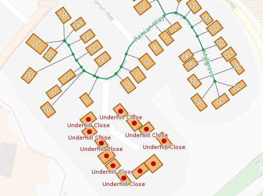
Resolution: The best option here would be to do a ground survey to check for the name on the street, and if you do this you’ll find a sign for Underhill Close. But what if a ground survey is not immediately possible – are there any other sources we can use? Well, we could look at the OS OpenData. I find that OS Musical Chairs is a good site to use. In this case though, the Ordnance Survey don’t have the Underhill Close name (link). Another source is the Land Registry Price Paid data. Using the search form (link), I find this street name in their database.


Example 2: Incorrect street name change

This ones a bit more suitable, but highlights the benefit of mapping residential addresses. In the example the street name changes from Throckmorton Road to St Mary’s Road. I had originally mapped the transition of street name at the intersection with Winchcombe Road (to the north). My adding the addresses it is clear that the transition between street names actually occurs further to the south-east.

OSM Inspector - Example 2

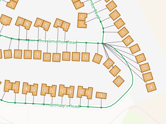
Resolution: In this case we can just change the point at which the street name changes in OpenStreetMap. Somewhere in the south east corner between numbers 83 and 29 will be fine.

EDIT: Why not take a look at what OSM Inspector shows in your neighbourhood.

Improving TagInfo

posted in: Use The Map | 0

TagInfo is a website that allows you to explore tag usage statistics in OpenStreetMap. That is, unlike the wiki documentation which describes how tags should be used, TagInfo reports on how tags are actually being used in OpenStreetMap.

I’ve previously written a bit about TagInfo in “Exploring OpenStreetMap Data” and I’m pleased to see that TagInfo continues to be improved with new features. One of these features was suggested by our own Andy Mabbett – lets take a look.

Comparing Keys and Tags

It is now possible to compare tags side by side on a single page. A new menu on tag (and key) pages allows you to add those tags to a comparison list and then compare them side by side. This new addition is great when when trying to decide which of several similar tags is best to use based on popularity/existing use.

Comparing two tags side by side in TagInfo.

Well done Andy for proposing this new feature, and a big thank you to Jochen Topf for implementing it so quickly.

Other new features

The tag comparison is not the only new update to TagInfo. Today the following updates were also added:

  • Maps for Tags
  • Link to Level0 Editor
  • Improved Overpass Turbo Integration

In addition to the above improvements, there are also changes to the API and new translations (you can help with translating TagInfo here).

TagInfo is a great tool to help OpenStreetMappers, so I’d personally like to thank Jochen for his work on this. TagInfo is now a core feature of OpenStreetMap (now being hosted on OpenStreetMap Foundation servers). This is a great accolade for TagInfo as it signifies that the website is at the heart of the OpenStreetMap landscape and will continue to be supported going forward.

Mike Duffy (OSM username Miked29)

posted in: Uncategorized | 0

It was the sad duty today for Andy Robinson and I to pay tribute to Mike’s contribution to OpenStreetMap at his memorial service, for Mike died on 28th April 2014, aged 78.

File0003

Mike was a stalwart of the local OSM community and had mapped large swathes of the Black Country and North Birmingham. He was a regular attendee at our social meetings and although his mobility was limited he did his share of walking streets to gather data in surveys  when we had our mini-mapping parties. Sometimes Mike might have to catch 3 buses to get to an event, but he’d always be there. Mike compensated for his limited surveycoverage on the ground by spending hundreds of fruitful hours armchair mapping from aerial imagery and Ordnance Survey OpenData.

If you’d like to see just how significant Mike’s contributions were, a summary can be found here

Those of you attended SotM 2013 at Aston University in September 2013 may well remember Mike in his orange volunteer T-shirt (a much prized item of apparel according to his daughter Julie). He might well have issued you your delegate credentials, and if you bought a spare T-shirt you will almost certainly have bought it from Mike.

Our personal condolences from local mappa-mercia OSMers and organisational condolences from the wider OpenStreetMap community go to Mike’s children John and Julie and to his wider family and circle of friends.

Wherever Mike is now I’m sure he’s trying to map it!