Boundaries, be they land ownership or administrative boundaries, form an essential part of geo-data. Was it therefore a success for the open data campaign when Ordnance Survey released the Boundary-Line product, containing all electoral and administrative boundaries, under the OS OpenData Licence? Not Quite.
The problem is that boundary is the “Boundary-Line” data are not boundaries! There are two issues, and these apply to all geospatial data released as independent vector layers; scale and context.
Scale
Large scale maps (such as walking maps), have a higher resolution than medium, or small scale maps (such as country of global maps). The larger the scale, the higher the resolution and therefore the more detail shown. As boundaries twist and turn following streams, rivers and hedges, it is important to use a large scale/high resolution. The Ordnance Survey provide boundary data in two products; the free “Boundary-Line” product, and the non-free “OS MasrterMap” product. According to Ordnance Surveys own admission:
Boundary-Line is captured against a lower resolution mapping backdrop and the boundaries are captured to represent the data at a nominal 1:10000 viewing scale. The process of generalising the data may have caused some features to be moved from their true ground position for the purpose of map clarity.
So scale, or to give it it’s proper name, generalisation, is the first problem we should be aware of before using Boundary-Line data in OpenStreetMap.
Context
Lets see what Ordance Survey have to say about their other boundary product – OS MasterMap:
OSMM Topography Layer currently holds the definitive and more accurate boundary information as the boundaries are mered (aligned to) real-world features on the ground. Captured at mapping scales of 1:1250, 1:2500 (for urban areas) and 1:10k (for rural).
Okay, we can see that MasterMap uses a larger scale / higher resolution which helps provide more accurate data, but what is that reference to “mereing” (alignment). Mereing, is the process of establishing a boundary relative to ground features present at the time of a survey (source: ESRI). As such any boundary line extracted from a map of any resolution cannot therefore be used on its own to describe a boundary – once you extract the boundary, you loose the context provided by the rest of the map!
Lets look at an example.
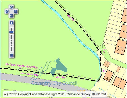
In the example above we see the boundary as a black dashed line. Along the line are some descriptions in pink. The first couple are relatively easy to decipher – “Co Const Met Dist & CP Bdy” is shorthand for County Constituency, Metropolitan District and Civil Parish boundary. Similarly “Boro Const Bdy” tells us it is a Borough Constituency boundary. As we follow the boundary we reach more abstract shorthand:
- 1.22m RH – RH stands for Root of Hedge, and 1.22m equates to exactly 4ft. The boundary is therefore 4ft away from the stem line of the hedge. This unusual convention comes from the presumption that landowners planted hedgerows slightly in from the edge of their land so as to not encroach on their neighbours plots. The distance differs between 3ft and 5ft depending on which parish the land lies within.
- Def – This is a “defaced boundary”, meaning that the original feature that the boundary was aligned to no longer exists. This was probably a hedge that was removed when the houses were built. Had the hedge roots not been removed then the boundary would be marked as “Tk H” implying track of hedge.
- Und – An “undefined boundary” is one where there was no real-world feature to align the boundary to when it was surveyed.
For a list of abbreviations click here.
Conclusion
Any vector extract of boundary data will be problematic due to generalisation (scale) and the loss of information about mereing (loss of context). If you are really keen on determining the exact boundary you may want to read more about boundary presumptions or go and dig out the original surveyors notes (Perambulation Cards) at the National Archives.
Discussion
So for OpenStreetMap should we be linking boundary ways to streams and hedges on the acknowledgement that Boundary-Line data is not perfect and we are not able to provide any certainty as to which side of the hedge the boundary actually resides on? Please leave your thoughts as comments below.
petrina foster
What is the definition of a Boundary Mereing Symbol as I have been advised by OS that this refers to Council or Parish Council markings on a map for administration purposes but they do not confirm the boundary of a property or field. Is that correct?
Leigh
Yes this is correct
H. Hartnlell
The link to the list of abbreviation now gives a “404” broken link.
What does “FF” mean?
H. Hartnlell
I think I have answered my own question.
With thanks to:
http://www.boundary-problems.co.uk/boundary-problems/osmaps.html
CH = Centre of Hedge
0.91m RH = 0.91m from Root of Hedge
CW = Centre of Wall
FF = Face of Fence
FW = Face of Wall
BB – Base of Bank
TB = Top of Bank
EK = Edge of Kerb
A range of distances from a linnear feature such as a Root of Hedge or Top of Bank may be applied, 0.91 m (3 ft), 1.22m (4 ft) and 1.52 m (5 ft) being the most common.
Adrian
If my property title plan “red line” (property built in 1975)runs up to a historical hedge line noted on a OS map
dated 1842-1952 and there is also 5Ft RH written, would that indicate that the boundary drawn would be 5Ft from the root of the hedge or in my case an old oak tree that dates 100+ years.
In addition, there is a ditch and the oak tree has grown from the mound on my side of the ditch