OpenStreetMap alternatives to Google’s Maps Engine and Fusion Tables

posted in: Use The Map | 13

Often we just want to produce a simple map showing data as a collection of pins (map markers). In this post we look at two tools that both use OpenStreetMap base maps; namely geojson.io and uMap. These are both potential alternatives to Google Maps Engine and Fusion Tables. 

OpenStreetMap has come a long way in the last 10 years; we’ve reached 1.7 million registered users, over 300,000 of whom are the last editor an an object in OpenStreetMap, and we’ve contributed over 2.4 billion nodes (points) and 248 million ways (linear features). This has led to OpenStreetMap being deployed by large companies such as Apple, Mapquest and Foursquare, and relief organisations such as Médecins Sans Frontières.

However when it comes to individuals – including those who associate themselves with the Open Source or Open Data communities – many people stick with what they know. More often that not that’s Google. OpenStreetMap is quite different; as it’s not a traditional company, most of the interesting stuff is going on outside of the core openstreetmap.org website. Let’s look at two online tools that use OpenStreetMap for the base map display.

Geojson.io

Geojson.io describes itself as “a quick, simple tool for creating, viewing, and sharing map”. It has a strong focus on input/output (io) as it supports major formats such GeoJSON, KML, GPX, CSV, TopoJSON, amongst other formats listed on the OpenStreetMap wiki. The inputs can be from a file, from a GitHub (including Gist snippets) or added manually via the website’s user interface. The final map can be exported to file, to GitHub or shared as an embeddable iframe or as a standalone URL. Visual customisation is limited to a choice of three map backgrounds.

Example:

In this example I have a geojson file of pubs in and around Stratford-upon-Avon. All the data is as points (nodes) and I want to produce a simple map to display in this blog post. Using geojson.io the steps are:

  1. Go to geojson.io.
  2. Click Open and load the source file. The map data can then be edited in the right hand pane (I used the table edit to drop some columns)
  3. Pick a map background from the choice of Mapbox, Satellite and default OSM from the options in the bottom left.
  4. Click Share and copy and paste the embeddable iframe.

Here is the result:

Quick, simple and effective.

uMap

Similar to geojson.io above, uMap describes itself as a way to “create maps with OpenStreetMap layers in a minute and embed them in your site”. It supports a number of import formats including geojson, csv, kml and also allows you to draw content directly on the map. On the export side, you can download the map data in three different file formats, or share it via an embeddable iframe or stand alone URL. Unlike geojson.io, uMap has numerous customisation options, for example you can pick from 16 map backgrounds, map data can be styled with a colour, fill opacity and line type, and the popup content can be adjusted to display additional information such as images and web links. uMap also enables you to easily work collaboratively on a map. This flexibility does however make the user interface more complicated than geojson.io’s.

Example:

This example uses a file of school locations in and around Lichfield. Most of the data is stored as polygons, however it also include point data. As before the aim is to produce a simple map to display in this blog post. Using uMap the steps are:

  1. Go to umap.openstreetmap.fr or one of the alternate instances listed here.
  2. Click Create a map.
  3. Click Import data (the up arrow icon on the right or keyboard shortcut Ctrl+I).
  4. Customise using the options on the right. Here I’ve changed the map background to MapQuest Open.
  5. Click More on the left hand side, followed by Embed and share this map.
  6. Copy and paste the embeddable iframe (I also had to click Current view instead of deafult map view in the iframe options box.

Here’s the result from uMap:

Advanced, customisable, and featureful.

Tell us what you think

Have a go and let us know what you think. How do they compare with what is available from Google or others, and what would make them better. Drop us a line in the comment box below or via our twitter account, @mappamercia.

Tell us: Where is the Midlands most unusual listed building?

posted in: Observations, Participate | 1

Here in England we are lucky to be surrounded by many historic buildings , and indeed our heritage is a big attraction for local and overseas tourists alike. To ensure that the most significant of our historic buildings are protected for future generations to enjoy, a building may designated as a “Listed Building”. Once on this register a building has statutory protection and  may not be demolished, extended, or altered without special permission from the local planning authority. The register, which is maintained by English Heritage, is published online and we’ve also produced our own heritage map for the West Midlands using this data.

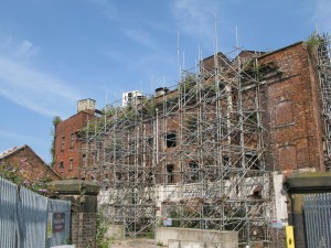
It’s very expensive to own and maintain a listed building, so unfortunately a  significant proportion of them fall into serious states of decay. This is the Old Steam Mill in Wolverhampton not far from the station:

IMG_7299
Wolverhampton’s Old Steam Mill – a Grade II listed building in need of some urgent attention

Many buildings and structures do not make it through the rigorous selection procedure to become listed, but still have some architectural or historical interest, so local authorities maintain “local lists”.  Locally-listed buildings do not have statutory protection so developers can do what they like with them, often demolishing them; but local planners will use all their powers of persuasion to preserve them. For example, Coventry’s local list can be found here.

“It has six wide ‘zebra’ stripes painted in white onto the Tarmac road surface, flanked by two lines of dashed marks either side…”

“Buildings” is perhaps a poor description, for the register can contain any historic structure. In the Midlands for example we have listed bridges, milestones, canal locks, telephone boxes, sewer ventilation pipes, tunnel entrances, fountains, bandstands, statues and monuments. Meanwhile in north London the Abbey Road zebra crossing  – made famous after appearing on a Beatles album cover – was added to the register of listed buildings and structure in late 2010.

Abbey Road zebra crossing – a Grade II listed ‘building’ getting plenty of attention

There are also some very interesting structures to be found in local lists. Wolverhampton City Council has locally listed  “Margery Cabinets”: these are electricity distribution cabinets designed by T.A.G Margery, the then Borough Electrical Engineer about 1930.

Today we’re asking you – where is the Midlands most unusual listed building structure? We’re not limiting it to just Birmingham, or just the West Midlands; feel free to explore the outer edges of the Midlands. If you think it counts, we want to hear about it. Drop us a message using the comment section below, or contact us @mappamercia on twitter.  A picture would help enormously.

A missing ‘l’ adds 5 miles

posted in: Map Improvements, Mapping Party | 3

When I first started contributing to OpenStreetMap there was a Project of the Week section on the OSM wiki. After much success this eventually came to and end in July 2011. Now, after a three year break, its back in the form of a “wochenaufgabe” (weekly task), for it is the German OpenStreetMap community that has brought back this weekly project.

This weeks task revolves around adding street names to buildings and suggests contributors use the Geofabrik OSM Inspector tool I previously blogged about. Given that I recently helped to map buildings as part of our Shenstone meet-up, I thought I best check the quality of our evenings work.

OSM Inspector unknown close

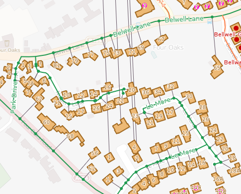
As it turns out, my attention was quickly diverted to the neighbouring town of Sutton Coldfield. As shown in the image above there are a collection of houses in Four Oaks that have a street name that links to Aston Close in Shenstone, 5 miles north (as seen by the lines heading north from each property). The buildings are tagged with addr:street=Aston Close, whilst the nearby Sutton Coldfield street is tagged name=Alston Close. So which is correct – Alston or Aston. We could go back out an survey this close, or turn to OpenData in the form of Land Registry’s Price Paid data.

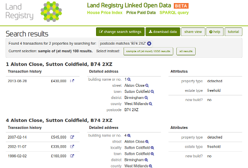
Alston Close in Land Registry price paid data

A quick search of the Price Paid data identifies the Sutton Coldfield street as Alston Close. No longer will you end up 5 miles out of the way next time you use OSM to route to this street.

Happy 10th birthday OSM!

posted in: Mapping Party | 1

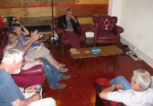
Appropriately 10 of us gathered at 6/8Kafé to celebrate 10 years of OSM. It was satisfying to see that our email campaign of contacting most users who had contributed to OSM in the midlands brought along six people to their first OSM meeting in the Midlands. We had users from Oxford,Worcester, Coventry and Stafford as well as the usual crowd from Birmingham (well….  minus a few notable examples who had very good excuses!) Thanks to everyone who gave up their time to come along,  I think we all gained something from swapping experiences  and tips and tricks for editing and tagging and data sources. Apologies to Steve Coast, our founder, who still has 12 ways in our region showing him as the last editor – we didn’t have the time or resources to invite contributors with this number of edits.

Naturally we had a cake, baked and decorated by Liz. Here’s  a Level 1 aerial image:

OSM10 Level1

I hope people remember which slice they were allocated- we’ll be expecting some edits!

In true OSM Mapping Party tradition there has to be an image of AFTER:

OSM10after

And of course we need to see who turned up:

OSM10Group OSM10 Andy

And finally thanks to Sal and her crew at 6/8Kafé  on Temple Row who generously donated a venue for us in their basement. Any OSMers visiting Birmingham, pop in for coffee and cake, you won’t be disappointed – beats the corporate coffee chains hand down.

IF YOU’RE ORGANISING YOUR OWN PARTY –  HAVE FUN

An unusual find- in more ways than one!

On 31st July the mappa-mercia gang of mappers descended on Shenstone for our monthly pub meeting. It was a glorious summer’s evening which confirmed our strategy of getting out and about around the region during the summer months to take advantage of the late evenings to combine some mapping with our usual meeting . For Shenstone we had a set ourselves the challenge to see if we could map a complete village in one evening. We did cheat slightly by pre-populating the buildings from armchair Bing aerial imagery tracing. We almost got there but not quite!

To the North of the village we came across a small memorial commemorating “Shenstone Lammas Land”. Now we all believe we know what Common Land is, it being a familiar presence in rural England, but Lammas Land had us all guessing. So a quick Google search soon informed us.

Lammas land’ is land with ‘common grazing rights’, which are grazing rights belonging to those commoners who had registered the right to graze their animals on the land.

Lammas rights go back to the middle ages, but only existed between August 1st (Lammas Day) and February 1st (Candlemas), when the animals were removed to allow crops (usually hay) to be grown for harvesting in mid summer. Then on Lammas day the animals were returned to graze off the stubble.

You can read about the villagers’ 25 year legal campaign to preserve their rights here, which successfully concluded as recently as 1998.

What a coincidence to come across this piece of Lammas Land on the eve of Lammas Day!